 EEA geospatial data catalogue
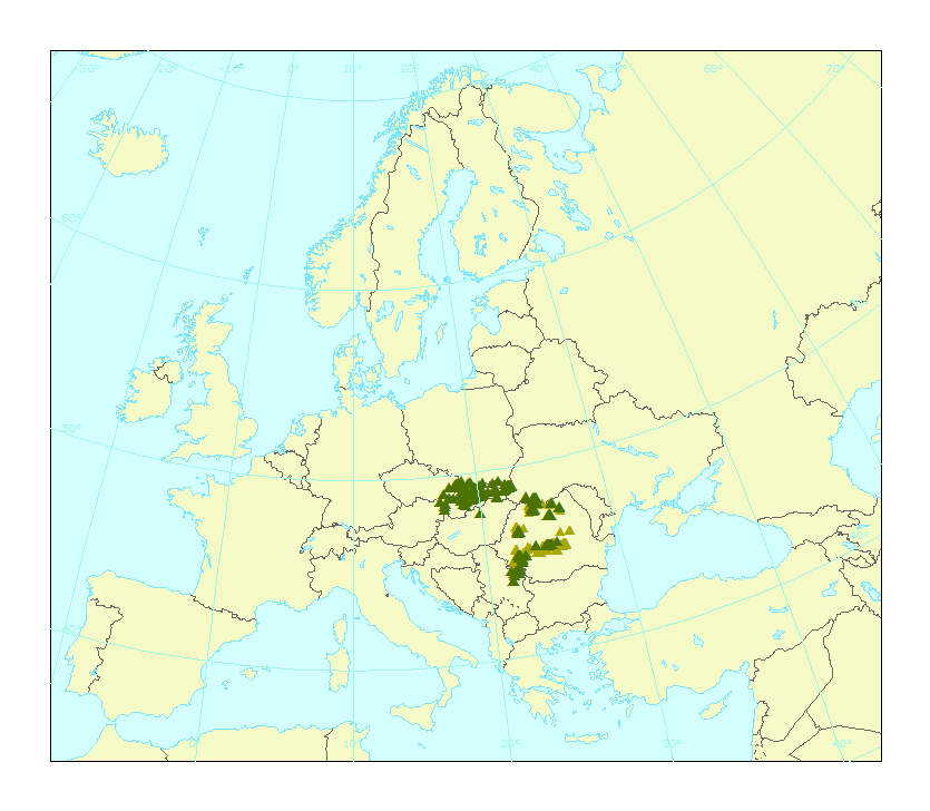
Virgin forest inventory of the Carpathians (KEO), version 1, Dec. 2019
The virgin forest inventory data set includes the location (point) of the last virgin forests identified by each Carpathians Convention Member, namely Czechia, Hungary, Romania, Serbia, Slovakia, and Ukraine. The data set does not include plots from Poland, since no official inputs have been submitted yet. An additional layer presents the quasi virgin forest plots provided by Romania. The virgin forest inventory inputs were collected and validated in 2019.
The attribute table indicates, when available and along the virgin forest location, additional information as the official name, size, the county to which it belongs, altitude, level of protection, the forest type according to the national classification and its correspondence with the European Nature Information System classes (EUNIS). The Carpathians area of study is delimited by the Carpathian Environment Outlook (KEO) boundary.
Simple
Identification info
- Date (Creation)
- 2019-12-19
- Edition
-
01.00
- Citation identifier
- scc_v_3035_10_k_virgin-forest-inventory-keo_i_2019_v01_r00
- Point of contact
-
Organisation Individual Electronic mail address Website Role European Environment Agency
Point of contact European Environment Agency
Custodian
- Spatial representation type
- Vector
Spatial resolution
Equivalent scale
- Denominator
- 10000
- Topic category
-
- Environment
Extent
))
Temporal extent
- Time period
- 2019-01-01 2019-12-15
Extent
- Maintenance and update frequency
- As needed
- GEMET
-
-
inventory
-
forest conservation
-
land use
-
forest ecosystem
-
land cover
-
forest biodiversity
-
- Continents, countries, sea regions of the world.
-
-
Hungary
-
Ukraine
-
Serbia
-
Czechia
-
Romania
-
Slovakia
-
- Spatial scope
-
-
Regional
-
- EEA topics
-
-
Biodiversity
-
Forests and forestry
-
Nature protection and restoration
-
Resource constraints
- Access constraints
- Other restrictions
Resource constraints
- Use constraints
- Other restrictions
- Other constraints
-
This data set is created in the agreement framework between the Carpathian Convention Secretariat, the Environmental European Agency (EEA) and the European Topic Centre on Urban, Land, and Soil Systems (ETC/ULS) to support the Carpathian Convention Working Group on Forest. The source data are owned by the Member Parties of the Carpathian Convention. The data set cannot be made freely available but can be granted access on demand.
Associated resource
- Association Type
- Cross reference
- Language
- English
Data quality info
- Hierarchy level
- Dataset
Report
Result
- Title
-
Commission Regulation (EU) No 1089/2010 of 23 November 2010 implementing Directive 2007/2/EC of the European Parliament and of the Council as regards interoperability of spatial data sets and services
- Date (Publication)
- 2010-12-08
- Explanation
-
See the referenced specification
Resource lineage
- Statement
-
The dataset is based on the forest plot location provided in tabular format by the Convention Member Parties. The data creation includes a harmonization process to have a consistent database, on the coordinate projection, naming and attributes used. The main efforts were focused on the translation of national forest species into a common EU standard, namely the European Nature Information System (EUNIS) within the support of local experts from the Members of the Convention, which have as well validated this resulting dataset at the end of the process.
- Hierarchy level
- Dataset
Reference System Information
Reference System Information
- Code
- EPSG:3035
Metadata
- Metadata identifier
- 571259cc-97da-45a5-acbb-d4f95a164a2b
- Language
- English
- Character encoding
- UTF8
- Contact
-
Organisation Individual Electronic mail address Website Role European Environment Agency
Point of contact
Type of resource
- Resource type
- Dataset
- Metadata linkage
-
https://sdi.eea.europa.eu/catalogue/srv/api/records/571259cc-97da-45a5-acbb-d4f95a164a2b
- Date info (Creation)
- 2020-03-03T07:34:14Z
- Date info (Revision)
- 2025-10-09T10:51:35.883576Z
Metadata standard
- Title
-
ISO 19115/19139
- Edition
-
1.0
)))