 EEA geospatial data catalogue
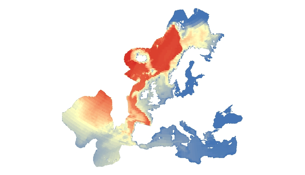
Probability of whales occurrence in Europe Seas, Jun. 2020
This raster dataset represents the probability of occurrence of whales in the Europe Seas, where the species included are: Blue whale, Sei whale, Humpback whale, Sperm whale, Fin whale and Northern right whale.
The northern right whale model only describes the range of the western population of this species, since the eastern population is probably almost extinct. Thus, the northern right whale model only partly overlaps with the EEA area on interest.
This dataset is based on AquaMaps distribution maps (version 10/2019). The dataset has been prepared in the context of the development of the first European Maritime Transport Environmental Report (EMSA-EEA report, 2021: https://www.eea.europa.eu/publications/maritime-transport).
Simple
Identification info
- Date (Creation)
- 2019-11-01
- Date (Publication)
- 2020-06-16
- Edition
-
01.00
- Citation identifier
- eea_r_3035_10_km_whales-occurrence_p_2019_v01_r00
- Point of contact
-
Organisation Individual Electronic mail address Website Role European Environment Agency
Point of contact European Environment Agency
Custodian
- Spatial representation type
- Grid
Spatial resolution
- Spatial resolution
- 0.5 deg
Spatial resolution
- Spatial resolution
- 10 km
- Topic category
-
- Environment
- Oceans
Extent
))
Temporal extent
- Time period
- 2019-10-01 2019-10-31
- Maintenance and update frequency
- As needed
- GEMET
-
-
sea
-
environment
-
aquatic environment
-
environmental quality
-
ocean
-
whale
-
marine ecosystem
-
marine biology
-
marine environment
-
- Continents, countries, sea regions of the world.
-
-
North Sea
-
Celtic Sea
-
Ionian Sea
-
Bay of Biscay
-
Kattegat
-
Iceland Sea
-
English Channel
-
Norwegian Sea
-
Barents Sea
-
Adriatic Sea
-
Baltic Sea
-
Mediterranean Sea
-
Northeast Atlantic Ocean (40W)
-
Black Sea
-
- Spatial scope
-
-
European
-
- EEA Management Plan
-
-
2021 1.2.5
-
Resource constraints
- Access constraints
- Other restrictions
- Other constraints
- no limitations to public access
Resource constraints
- Use constraints
- Other restrictions
- Other constraints
-
License CC-BY 4.0 ( https://creativecommons.org/licenses/by/4.0/). Copyright holder: European Environment Agency (EEA).
- Language
- English
Distribution Information
Data quality info
- Hierarchy level
- Dataset
Report
Result
- Title
- Commission Regulation (EU) No 1089/2010 of 23 November 2010 implementing Directive 2007/2/EC of the European Parliament and of the Council as regards interoperability of spatial data sets and services
- Date (Publication)
- 2010-12-08
- Explanation
-
See the referenced specification
Resource lineage
- Statement
-
The dataset has been created based on computer generated distribution maps from https://www.aquamaps.org/, version 10/2019. The values of the distribution models for the whale species were summed to 0.5-degree c-squares .
- Hierarchy level
- Dataset
Reference System Information
Reference System Information
- Code
- EPSG:3035
Metadata
- Metadata identifier
- 5b83a3ca-2545-4b9e-a294-e709be063059
- Language
- English
- Character encoding
- UTF8
- Contact
-
Organisation Individual Electronic mail address Website Role European Environment Agency
Point of contact
Type of resource
- Resource type
- Dataset
- Metadata linkage
-
https://sdi.eea.europa.eu/catalogue/srv/api/records/5b83a3ca-2545-4b9e-a294-e709be063059
- Date info (Creation)
- 2020-06-16T13:07:42Z
- Date info (Revision)
- 2025-10-09T10:52:28.405172Z
Metadata standard
- Title
-
ISO 19115/19139
- Edition
-
1.0
)))