 EEA geospatial data catalogue
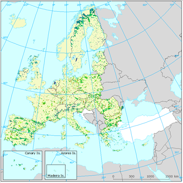
Potential quiet areas in Europe, based upon Quietness Suitability Index (QSI) and Natura 2000 protected areas, Jul. 2016
Within the European Union, the Environmental Noise Directive (END; 2002/49/EC) defines quiet areas outside cities as those areas delimited by national authorities that are undisturbed by noise from traffic, industry or recreational activities. In this dataset, two datasets has been brought together to visualize how human made noise have an impact on nature protected areas: the Natura2000 dataset and the quietness suitable index dataset.
The data set is provided by countries both in Geodatabase and Geopackage formats.
Simple
Identification info
- Date (Creation)
- 2016-07-11
- Date (Publication)
- 2016-07-11
- Edition
-
01.00
- Citation identifier
- eea_r_3035_100_m_quietareas-qsi-n2k_p_2016_v01_r00
- Citation identifier
- DAT-210-en
- Point of contact
-
Organisation Individual Electronic mail address Website Role European Environment Agency
Point of contact European Environment Agency
Custodian
- Spatial representation type
- Grid
Spatial resolution
- Spatial resolution
- 100 m
- Topic category
-
- Environment
Extent
))
Temporal extent
- Time period
- 2016-01-01 2016-12-31
Extent
- Maintenance and update frequency
- Not planned
- Continents, countries, sea regions of the world.
-
-
EEA33 (2013-2020)
-
- EEA Management Plan
-
-
2016 1.1.1
-
Resource constraints
- Use constraints
- Other restrictions
- Other constraints
-
License CC-BY 4.0 ( https://creativecommons.org/licenses/by/4.0/). Copyright holder: European Environment Agency (EEA).
Resource constraints
- Access constraints
- Other restrictions
- Other constraints
- no limitations to public access
- Language
- English
Data quality info
- Hierarchy level
- Dataset
Report
Result
- Title
- Commission Regulation (EU) No 1089/2010 of 23 November 2010 implementing Directive 2007/2/EC of the European Parliament and of the Council as regards interoperability of spatial data sets and services
- Date (Publication)
- 2010-12-08
- Explanation
-
See the referenced specification
Resource lineage
- Statement
-
Calculation and intersections of layers:
1. Calculation of QSI for european countries.
2. Intersection with Natura 2000 protected areas.
Data sources:
- END: major roads, major railways and major airports noise contour maps (2012)
- END: location of major roads and major railways and major airports
- Urban morphological zones (UMZ) from CLC 2006
- E-PRTR register: industries' location and attributes: Europe-wide register that provides easily accessible key environmental data from industrial facilities in European Union Member States and in Iceland, Liechtenstein, Norway, Serbia and Switzerland. It replaced and improved upon the previous European Pollutant Emission Register (EPER). Access 2014.
- Corine Land Cover and Land Use data 2006 (CLC) (100 × 100 m grid)
- Corine Land Cover 2000 for Greece
- EuroRegionalMap v. 6.0: roads, railways and airports infrastructure. (Version 6.0, 18.12.2012)
- Natura 2000
- The population of each UMZ in 2000 (year of reference) was added by using the last version (v. 5) of the population density grid constructed by the European Commission research centre (Gallego, 2010). Raster data on population density using Corine Land Cover 2000 inventory.
- Hierarchy level
- Dataset
Reference System Information
Reference System Information
- Code
- EPSG:3035
Metadata
- Metadata identifier
- 5f48b250-1c1d-4f0c-a2cd-a8c44e42b1dc
- Language
- English
- Character encoding
- UTF8
- Contact
-
Organisation Individual Electronic mail address Website Role European Environment Agency
Point of contact
Type of resource
- Resource type
- Dataset
- Date info (Creation)
- 2019-03-29T13:41:21Z
- Date info (Revision)
- 2025-10-09T10:53:21.958765Z
Metadata standard
- Title
-
ISO 19115/19139
- Edition
-
1.0
)))