 EEA geospatial data catalogue
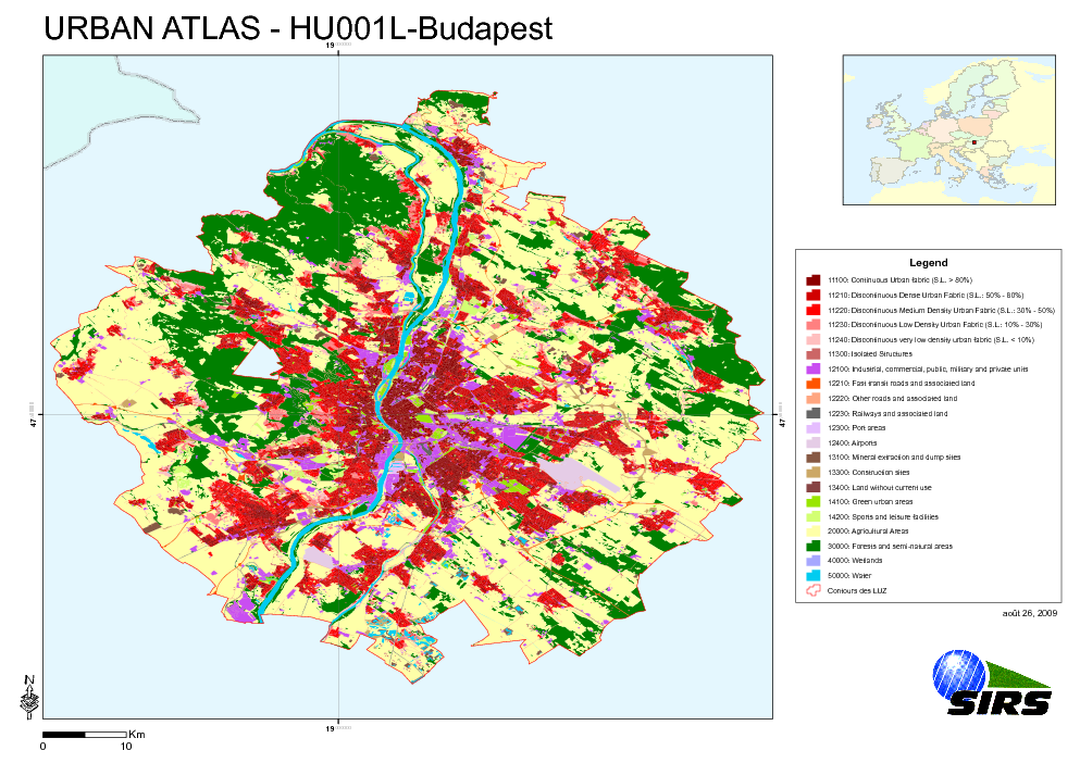
Urban Atlas - Hungary - Budapest
The Urban Atlas is providing pan-European comparable land use and land cover data for Large Urban Zones with more than 100.000 inhabitants as defined by the Urban Audit. Urban Atlas' mission is to provide high-resolution hotspot mapping of changes in urban spaces and indicators for users such as city governments, the European Environment Agency (EEA) and European Commission departments.
Simple
Identification info
- Date (Publication)
- 2010-05-28
- Date (Creation)
- 2010-05-28
- Citation identifier
- regio_v_32634_10_k_ua-hu001l_p_2006-2008_v01_r00
- Status
- Obsolete
- Point of contact
-
Organisation Individual Electronic mail address Website Role European Environment Agency
Point of contact
- Spatial representation type
- Vector
Spatial resolution
Equivalent scale
- Denominator
- 10000
- Topic category
-
- Society
Extent
))
Extent
Temporal extent
- Time period
- 2006-09-28 2008-08-19
- GEMET - INSPIRE themes, version 1.0
-
-
Land use
-
- GEMET
-
-
urban area
-
land use
-
- Place
-
-
Hungary
-
Budapest
-
- EEA topics
-
-
Land use
-
Resource constraints
- Use constraints
- Other restrictions
- Other constraints
-
License CC-BY 4.0 ( https://creativecommons.org/licenses/by/4.0/). Copyright holder: Directorate-General Enterprise and Industry.
Resource constraints
- Access constraints
- Other restrictions
- Other constraints
- no limitations to public access
- Language
- English
- Character encoding
- UTF8
Data quality info
- Hierarchy level
- Dataset
Report
Result
- Title
-
Commission Regulation (EU) No 1089/2010 of 23 November 2010 implementing Directive 2007/2/EC of the European Parliament and of the Council as regards interoperability of spatial data sets and services
- Date (Publication)
- 2010-12-08
- Explanation
-
See the referenced specification
Resource lineage
- Statement
-
Earth Observation (EO) Data used:
* Spot 5 2,50 m - 00182793034 (P) (Date: 2007/07/16)
* Spot 5 2,50 m - 00182793035 (P) (Date: 2007/07/31)
* Spot 5 2,50 m - 00182793036 (P) (Date: 2007/10/01)
* Spot 5 2,50 m - 00182793037 (P) (Date: 2007/07/31)
* Spot 5 2,50 m - 00182784034 (XS) (Date: 2007/07/31)
* Spot 5 2,50 m - 00182784035 (XS) (Date: 2006/09/28)
* Spot 5 2,50 m - 00182784036 (XS) (Date: 2007/07/15)
* Spot 5 2,50 m - 00182784037 (XS) (Date: 2008/08/19)
- Hierarchy level
- Dataset
Reference System Information
- Reference system identifier
- OGP Surveying & Positioning Committee/urn:ogc:def:crs:EPSG:7.1:32634
Metadata
- Metadata identifier
- 62275466-177f-4e7f-adf4-68c4df07c9d6
- Language
- English
- Character encoding
- UTF8
- Contact
-
Organisation Individual Electronic mail address Website Role European Environment Agency
Point of contact
Type of resource
- Resource type
- Dataset
- Metadata linkage
-
https://sdi.eea.europa.eu/catalogue/srv/api/records/62275466-177f-4e7f-adf4-68c4df07c9d6
- Date info (Creation)
- 2012-03-29T14:34:11Z
- Date info (Revision)
- 2025-10-09T10:53:56.848768Z
Metadata standard
- Title
-
ISO 19115/19139
- Edition
-
1.0
)))