 EEA geospatial data catalogue
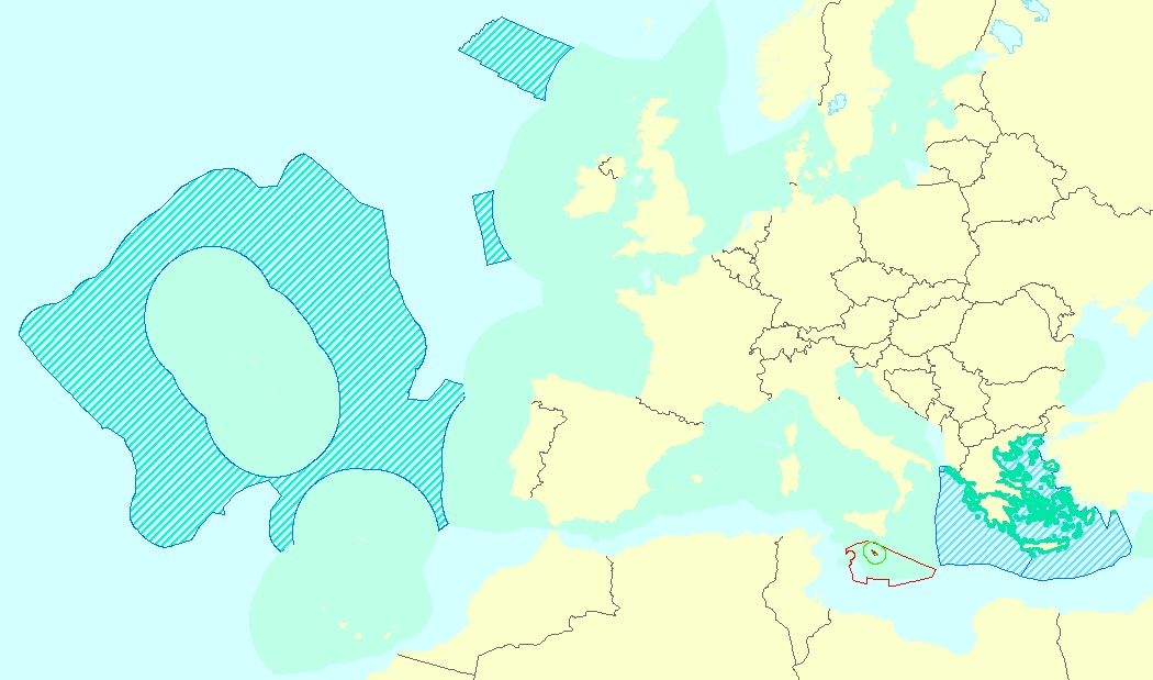
Marine waters used in Marine Strategy Framework Directive (MSFD) - version 1.0, May 2020
This vector data set is the first public version released of the EU marine waters used for the implementation of the Marine Strategy Framework Directive (MSFD), submitted by the Member States to the European Commission.
The Marine Strategy Framework Directive (MSFD) applies to all marine waters of EU Member States, which in Article 3 are defined as follows:
(a) waters, the seabed and subsoil on the seaward side of the baseline from which the extent of territorial waters is measured extending to the outmost reach of the area where a Member State has and/or exercises jurisdictional rights, in accordance with the UNCLOS, with the exception of waters adjacent to the countries and territories mentioned in Annex II to the Treaty and the French Overseas Departments and Collectivities; and
(b) coastal waters as defined by Directive 2000/60/EC, their seabed and their subsoil, in so far as particular aspects of the environmental status of the marine environment are not already addressed through that Directive or other Community legislation.
Simple
Identification info
- Date (Creation)
- 2020-05-15
- Date (Publication)
- 2020-05-30
- Edition
-
01.00
- Citation identifier
- eea_v_4258_100_k_msfd-marine-waters_p_2012-2018_v01_r00
- Citation identifier
- DAT-248-en
- Status
- Superseded
- Point of contact
-
Organisation Individual Electronic mail address Website Role European Environment Agency
Point of contact European Environment Agency
Custodian
- Spatial representation type
- Vector
Spatial resolution
Equivalent scale
- Denominator
- 100000
- Topic category
-
- Environment
- Oceans
Extent
))
Temporal extent
- Time period
- 2012-10-16 2018-10-15
- Maintenance and update frequency
- As needed
- GEMET
-
-
sea
-
marine environment
-
Marine Strategy Framework Directive
-
- Continents, countries, sea regions of the world.
-
-
Black Sea
-
Baltic Sea
-
Northeast Atlantic Ocean (40W)
-
Mediterranean Sea
-
- Spatial scope
-
-
European
-
- EEA Management Plan
-
-
2021 1.6.1
-
- EEA topics
-
-
Seas and coasts
-
Resource constraints
- Access constraints
- Other restrictions
- Other constraints
- no limitations to public access
Resource constraints
- Use constraints
- Other restrictions
- Other constraints
-
License CC-BY 4.0 ( https://creativecommons.org/licenses/by/4.0/). Copyright holder: European Environment Agency (EEA).
Associated resource
- Association Type
- Cross reference
- Metadata Reference
Associated resource
- Association Type
- Cross reference
Associated resource
- Association Type
- Cross reference
- Language
- English
Data quality info
- Hierarchy level
- Dataset
Report
Result
- Title
- Commission Regulation (EU) No 1089/2010 of 23 November 2010 implementing Directive 2007/2/EC of the European Parliament and of the Council as regards interoperability of spatial data sets and services
- Date (Publication)
- 2010-12-08
- Explanation
-
See the referenced specification
Resource lineage
- Statement
-
The present data set is a compilation of the layers submitted by Member States (in SHP format) to the European Commission as part of the implementation of the MSFD. For countries that haven't submitted the delimitation of their marine waters, the Marine Reporting Units used within the first reporting cycle (where the extent was limited to their waters) have been merged and dissolved. The marine waters of EU Member States are provided split by MSFD region/subregion and, where needed, by territorial waters and (extended) continental shelf, or other types of jurisdiction.
- Hierarchy level
- Dataset
Reference System Information
Reference System Information
- Code
- EPSG:4258
Metadata
- Metadata identifier
- 6d365112-5c0a-409e-bd45-68197fe3b2e8
- Language
- English
- Character encoding
- UTF8
- Contact
-
Organisation Individual Electronic mail address Website Role European Environment Agency
Point of contact
Type of resource
- Resource type
- Dataset
- Metadata linkage
-
https://sdi.eea.europa.eu/catalogue/srv/api/records/6d365112-5c0a-409e-bd45-68197fe3b2e8
- Date info (Creation)
- 2020-05-15T11:52:16Z
- Date info (Revision)
- 2025-10-09T10:56:26.804976Z
Metadata standard
- Title
-
ISO 19115/19139
- Edition
-
1.0
)))