 EEA geospatial data catalogue
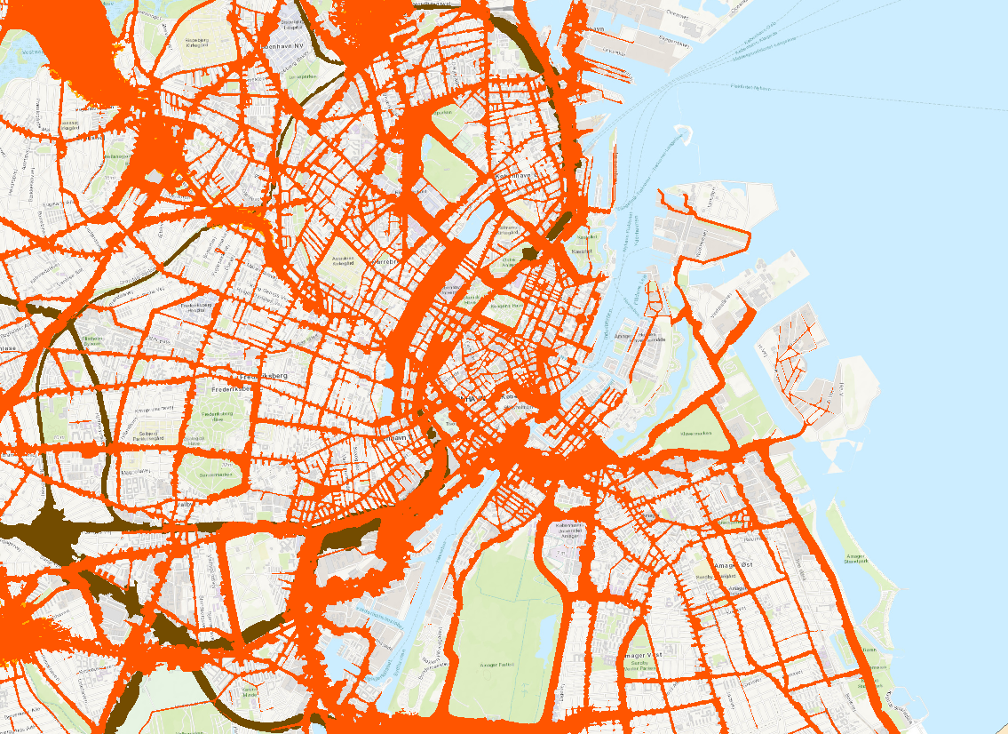
Noise contours data reported under Environmental Noise Directive (END) 2017 (vector) - version 2019, Oct. 2019
The data set includes the noise contours which have been reported by countries under the terms of the Environmental Noise Directive (END) by the 33 EEA member countries (EEA-33) excluding Türkiye for the third round of noise mapping in 2017. The data set includes submissions from the countries until 01/01/2019.
According to the END, for major sources of noise (i.e. major roads with more than 3 000 000 vehicle passages a year, major railways with more than 30 000 train passages per year and airports with more than 50 000 movements per year), countries have to submit noise contour maps for at least the >55 dB, >65 dB bands. Noise contour maps for roads, railways, airports and industries in urban agglomerations of more than 100 000 inhabitants need to be represented for at least 60, 65, 70 and 75 dB bands for the day-evening-night period.
The data set is provided in GDB and GPKG files, with all the reported noise contours in vector format by country or region/state (in the case of BE and DE), for major sources at agglomeration level and national level and for both indicators Lden (day-evening-night noise level: the long-term average indicator designed to assess annoyance defined by the END; it refers to an A-weighted average sound pressure level over all days, evenings and nights in a year, with an evening weighting of 5 dB and a night weighting of 10 dB) and Lnight (night noise level: the long-term average indicator defined by the END and designed to assess sleep disturbance; it refers to an A-weighted annual average night period of exposure).
Simple
Identification info
- Date (Creation)
- 2019-10-31
- Edition
-
01.00
- Citation identifier
- eea_v_3035_1_k_noise-contours-end2017_i_2016_v01_r00
- Point of contact
-
Organisation Individual Electronic mail address Website Role European Environment Agency
Point of contact European Environment Agency
Custodian
- Spatial representation type
- Vector
Spatial resolution
Equivalent scale
- Denominator
- 1000
- Topic category
-
- Environment
- Transportation
- Health
Extent
Temporal extent
- Time period
- 2016-01-01 2016-12-31
Extent
))
- Maintenance and update frequency
- As needed
- GEMET
-
-
noise monitoring
-
airport
-
motorway
-
railway
-
road
-
environmental noise
-
noise
-
- Continents, countries, sea regions of the world.
-
-
Liechtenstein
-
EU28 (2013-2020)
-
Switzerland
-
Iceland
-
Norway
-
- Spatial scope
-
-
European
-
- INSPIRE priority data set
-
-
Directive 2002/49/EC
-
Agglomerations - aircraft noise exposure delineation - night (Noise Directive)
-
Agglomerations - aircraft noise exposure delineation day-evening-night (Noise Directive)
-
Agglomerations - industrial noise exposure delineation day-evening-night (Noise Directive)
-
Agglomerations – industrial noise exposure delineation - night (Noise Directive)
-
Agglomerations - noise exposure delineation - night (Noise Directive)
-
Agglomerations - noise exposure delineation day-evening-night (Noise Directive)
-
Agglomerations - railways noise exposure delineation - night (Noise Directive)
-
Agglomerations - railways noise exposure delineation day-evening-night (Noise Directive)
-
Agglomerations - roads noise exposure delineation - night (Noise Directive)
-
Agglomerations - roads noise exposure delineation day-evening-night (Noise Directive)
-
Major airports noise exposure delineation - night (Noise Directive)
-
Major airports noise exposure delineation day-evening-night (Noise Directive)
-
Major railways noise exposure delineation - night (Noise Directive)
-
Major railways noise exposure delineation day-evening-night (Noise Directive)
-
Major roads noise exposure delineation - night (Noise Directive)
-
Major roads noise exposure delineation day-evening-night (Noise Directive)
-
- EEA topics
-
-
Noise
-
Pollution
-
Road transport
-
Transport and mobility
-
Environmental heatlh effects
-
Resource constraints
- Access constraints
- Other restrictions
Resource constraints
- Use constraints
- Other restrictions
- Other constraints
-
The full noise contour maps data set is in principle only available for EEA internal use. A public version of the data set may in the future be available, excluding those data sets for which there is any limitation or restriction in their use (beyond acknowledgement).
- Language
- English
Distribution Information
- Distribution format
-
-
Geopackage
-
GDB
-
- OnLine resource
-
Direct download (Eionet authentication)
Data quality info
- Hierarchy level
- Dataset
Report
Result
- Title
-
Commission Regulation (EU) No 1089/2010 of 23 November 2010 implementing Directive 2007/2/EC of the European Parliament and of the Council as regards interoperability of spatial data sets and services
- Date (Publication)
- 2010-12-08
- Explanation
-
See the referenced specification
Resource lineage
- Statement
-
The vector data set is an export in GDB and GPKG format from the Noise Spatial Database, which in turn contains all versions delivered by the relevant countries (EU and EFTA) to Reportnet (CDR). The data from Reportnet is automatically incorporated into the database, with the exception of those data sets which require a manual review (due to problems with naming conventions or Coordinate Reference System).
- Hierarchy level
- Dataset
Reference System Information
Reference System Information
- Code
- EPSG:3035
Metadata
- Metadata identifier
- 7aca9cbb-fb3e-49b3-9e10-578760eda277
- Language
- English
- Character encoding
- UTF8
- Contact
-
Organisation Individual Electronic mail address Website Role European Environment Agency
Point of contact
Type of resource
- Resource type
- Dataset
- Metadata linkage
-
https://sdi.eea.europa.eu/catalogue/srv/api/records/7aca9cbb-fb3e-49b3-9e10-578760eda277
- Date info (Creation)
- 2020-03-11T16:04:15Z
- Date info (Revision)
- 2025-10-09T10:59:02.70787Z
Metadata standard
- Title
-
ISO 19115/19139
- Edition
-
1.0
)))