 EEA geospatial data catalogue
Assessment of eutrophication status in European seas using HEAT+, May 2019
The dataset presents the results of classification of eutrophication status of the European seas using the HEAT+ tool. Eutrophication status is evaluated in five classes, where NPAhigh and NPAgood are recognised as ‘non-problem areas’ and PAmoderate, PApoor and PAbad are recognised as ‘problem areas’.
Besides the overall Eutrophication status (HEAT+) are the results shown for three aspects of eutrophication:
C1) Nutrient Concentrations
C2) Direct Effects
C3) Indirect Effects
This dataset underpins the findings and cartographic representations published in the report "Nutrient enrichment and eutrophication in Europe's seas" (EEA, 2019): https://www.eea.europa.eu/publications/nutrient-enrichment-and-eutrophication-in.
Simple
Identification info
- Date (Creation)
- 2019-05-08
- Date (Publication)
- 2020-01-13
- Edition
-
01.00
- Citation identifier
- eea_v_3035_20_km_heat-eutrophication_p_2006-2016_v01_r00
- Citation identifier
- DAT-217-en
- Point of contact
-
Organisation Individual Electronic mail address Website Role European Environment Agency
Point of contact European Environment Agency
Custodian
- Spatial representation type
- Vector
Spatial resolution
- Spatial resolution
- 20 km
Spatial resolution
- Spatial resolution
- 100 km
- Topic category
-
- Environment
Extent
))
Temporal extent
- Time period
- 2006-01-01 2016-12-31
- Maintenance and update frequency
- As needed
- GEMET
-
-
sea water
-
ecological status
-
marine environment
-
nutrient content
-
eutrophication
-
environmental quality
-
contamination
-
nutrient balance
-
sea
-
- Continents, countries, sea regions of the world.
-
-
Norwegian Sea
-
Barents Sea
-
Black Sea
-
Iceland Sea
-
Mediterranean Sea, Western Basin
-
Ionian Sea
-
Bay of Biscay
-
Aegean Sea
-
Celtic Sea
-
English Channel
-
Adriatic Sea
-
Mediterranean Sea
-
Kattegat
-
Baltic Sea
-
Mediterranean Sea, Eastern Basin
-
- Spatial scope
-
-
European
-
- EEA Management Plan
-
-
2019 1.6.2
-
- EEA topics
-
-
Seas and coasts
-
Water
-
Biodiversity
-
Resource constraints
- Access constraints
- Other restrictions
- Other constraints
- no limitations to public access
Resource constraints
- Use constraints
- Other restrictions
- Other constraints
-
License CC-BY 4.0 ( https://creativecommons.org/licenses/by/4.0/). Copyright holder: European Environment Agency (EEA).
Associated resource
- Association Type
- Cross reference
- Metadata Reference
Associated resource
- Association Type
- Cross reference
Associated resource
- Association Type
- Cross reference
Associated resource
- Association Type
- Cross reference
- Metadata Reference
Associated resource
- Association Type
- Cross reference
- Metadata Reference
Associated resource
- Association Type
- Cross reference
- Metadata Reference
Associated resource
- Association Type
- Cross reference
Associated resource
- Association Type
- Cross reference
- Metadata Reference
Associated resource
- Association Type
- Cross reference
- Metadata Reference
- Language
- English
Distribution Information
- Distribution format
-
-
SHP
-
- OnLine resource
-
Direct download
- OnLine resource
-
EEA website - graphic
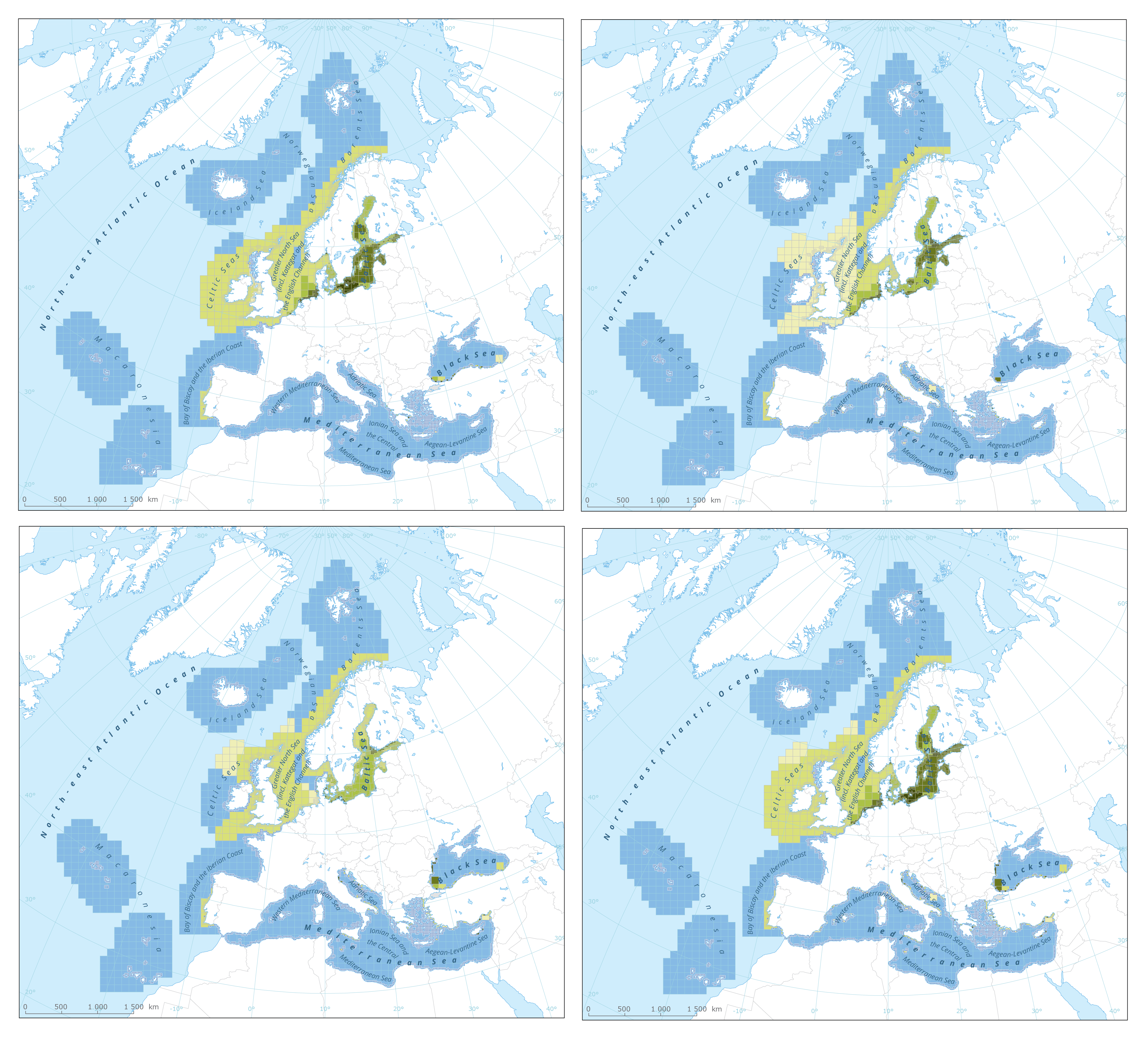
HEAT+ based classifications of 'direct effects' of eutrophication
- OnLine resource
-
EEA website - graphic
HEAT+ based classification of 'nutrient concentration levels'
- OnLine resource
-
EEA website - graphic
HEAT+ based classifications of 'indirect effects' of eutrophication
- OnLine resource
-
EEA website - graphic
Integrated HEAT+ based classifications of 'eutrophication status'
- OnLine resource
-
https://water.discomap.eea.europa.eu/arcgis/rest/services/Marine/HEAT_Eutrophication/MapServer
- OnLine resource
-
WMS
Data quality info
- Hierarchy level
- Dataset
Report
Result
- Title
- Commission Regulation (EU) No 1089/2010 of 23 November 2010 implementing Directive 2007/2/EC of the European Parliament and of the Council as regards interoperability of spatial data sets and services
- Date (Publication)
- 2010-12-08
- Explanation
-
See the referenced specification
Resource lineage
- Statement
-
Results of classification of Eutrophication Status using the HEAT+ tool. Eutrophication status is evaluated in five classes:
NPAhigh and NPAgood are recognised as ‘non-problem areas’
PAmoderate, PApoor and PAbad are recognised as ‘problem areas’
The results are shown for 3 aspects of eutrophication:
C1) Nutrient Concentrations
C2) Direct Effects
C3) Indirect Effects
All results are summed up in the layer HEAT+) the overall Eutrophication status
More information can be found in the report "Contaminants in Europe's seas" and online material on https://www.eea.europa.eu/publications/contaminants-in-europes-seas/.
- Hierarchy level
- Dataset
Reference System Information
Reference System Information
- Code
- EPSG:3035
Metadata
- Metadata identifier
- 7c66cfd5-4246-4b9d-86af-624950aa49d4
- Language
- English
- Character encoding
- UTF8
- Contact
-
Organisation Individual Electronic mail address Website Role European Environment Agency
Point of contact
Type of resource
- Resource type
- Dataset
- Metadata linkage
-
https://sdi.eea.europa.eu/catalogue/srv/api/records/7c66cfd5-4246-4b9d-86af-624950aa49d4
- Date info (Creation)
- 2020-01-13T13:42:40Z
- Date info (Revision)
- 2025-10-09T10:59:27.516976Z
Metadata standard
- Title
-
ISO 19115/19139
- Edition
-
1.0
)))