 EEA geospatial data catalogue
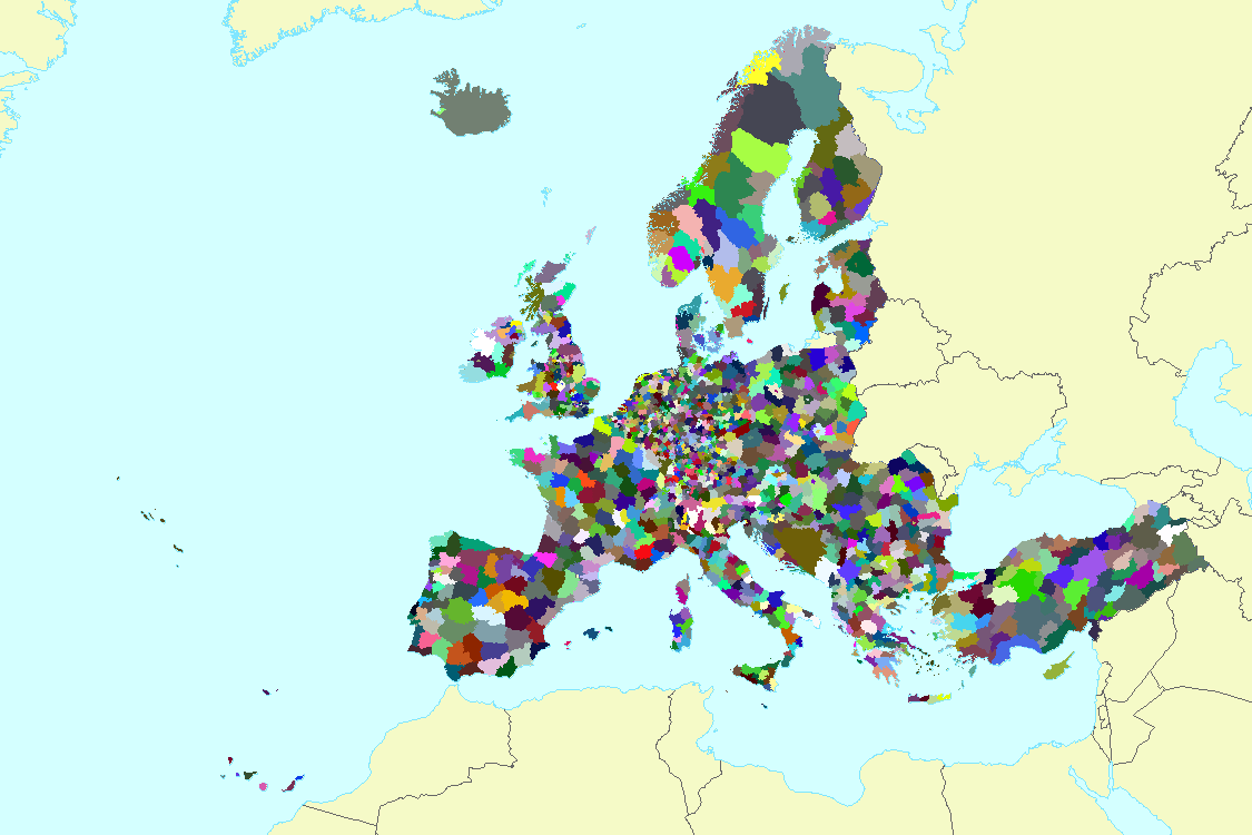
Administrative boundaries of EEA39 (NUTS 2016, aligned with Corine Land Cover 2012), Apr. 2018
The dataset represents the administrative boundaries of the 39 EEA countries at various aggregation level following NUTS 2016 classification: Country (NUTS0), NUTS1, NUTS2, and NUTS3 regions.
The dataset is created in raster format with a spatial resolution of 100m grid size. Spatial extent of the dataset is adjusted to the latest Corine Land Cover product [Corine Land Cover 2012 (raster 100m) - version 18, Sep. 2016]. This dataset is created as a reference layer for performing spatial analysis and calculating statistics at country level for the European territory as needed by accounting activities such as Land and Ecosystem Accounting (LEAC).
Administrative boundaries were derived from the EUROSTAT GISCO dataset [European Commission, Eurostat (ESTAT), GISCO -Nomenclature of Territorial Units for Statistics 2016 (NUTS), Mar. 2018], EuroGeographics product [EuroBoundaryMap (full European coverage) - version 12, Jan. 2018], and coastal areas were derived from the Economic Exclusive Zone dataset [version 10.0 available in marineregions.org].
Simple
Identification info
- Date (Creation)
- 2018-04-15
- Citation identifier
- eea_r_3035_100_m_adm-boundaries-eea39_p_2016-2017_v01_r00
- Point of contact
-
Organisation Individual Electronic mail address Website Role European Environment Agency
Point of contact European Environment Agency
Custodian
- Spatial representation type
- Grid
Spatial resolution
- Spatial resolution
- 100 m
- Topic category
-
- Environment
Extent
))
Temporal extent
- Time period
- 2016-01-01 2017-12-31
- Maintenance and update frequency
- As needed
- GEMET - INSPIRE themes, version 1.0
-
-
Statistical units
-
Geographical names
-
Administrative units
-
- GEMET
-
-
administrative boundary
-
national boundary
-
sub-national boundary
-
- Continents, countries, sea regions of the world.
-
-
EEA39
-
Resource constraints
- Use constraints
- Other restrictions
- Other constraints
-
License CC-BY 4.0 ( https://creativecommons.org/licenses/by/4.0/). Copyright holder: European Environment Agency (EEA).
Resource constraints
- Access constraints
- Other restrictions
- Other constraints
- no limitations to public access
- Language
- English
- Character encoding
- UTF8
Distribution Information
- Distribution format
-
-
GeoTIFF
-
- OnLine resource
-
Direct download
- OnLine resource
-
0
ADM_EEA39
Data quality info
- Hierarchy level
- Dataset
Report
Result
- Title
- Commission Regulation (EU) No 1089/2010 of 23 November 2010 implementing Directive 2007/2/EC of the European Parliament and of the Council as regards interoperability of spatial data sets and services
- Date (Publication)
- 2010-12-08
- Explanation
-
See the referenced specification
Resource lineage
- Statement
-
The administrative boundaries from the different sources have been merged and then rasterized at 100 m resolution to fully cover the extent of the CLC land mask. Source data used are: GISCO for the official NUTS countries 2016, EuroBoundaryMap version 12.0 (for the EEA39 countries not available in GISCO dataset, being Bosnia and Herzegovina, Albania, Montenegro, Kosovo (UNSCR 1244/99), Gibraltar, Isle of Man, Jersey and Guernsey) and Economic Exclusive Zone version 10.0 for assigning a country value to those coastal water pixels available in CLC but not defined by the other source products used.
The spatial extent and grid size of the resulting raster is matching with the CLC land mask v18.5 [CLC 2012 reference land mask (resolution 100m), Apr. 2016].
The lookup table[AdmBound_EEA39_lookup.csv] can be linked joining the attribute “ID_ADM” with the raster “value”.
The table details code and label for NUTS, 3, 2, 1 and 0 levels.
Sea pixels are derived at NUTS0 level (and replicated for the other levels), defined as [code_country] + "_SEA" (e.g. ES_SEA)
Disputed sea areas are defined as [code_country1]+[code_country2] + "_SEA"
Disputed land areas are defined as "No Country", with ADM_ID = 8888
In the same way, countries which are not part of the EEA39 but are available in CLC (San Marino, Vatican) are defined as "No Country", with ADM_ID = 8888.
The "TAA" code and "TAA_DESN" description fields help in differentiate pixels among "Land Area", "Inland Water", Coastal Water, "Special Area" and "No Country" values.
The attribute table has a column for each country group (see list below), with Boolean value (e. 1/0) to facilitate the selection.
EEA39: EEA33 + EEA cooperating countries (Albania, Bosnia and Herzegovina, the North Macedonia, Montenegro, Serbia, Kosovo under the UN Security Council Resolution 1244/99)
EEA33: EEA32 + Croatia
EEA32: 32-Member Countries of the EEA (EU15 + EU10 + EFTA4 + Romania, Bulgaria and Türkiye)
EFTA4: Iceland, Liechtenstein, Norway, Switzerland
EU15: Austria, Belgium, Denmark, Finland, France, Germany, Greece, Ireland, Italy, Luxembourg, the Netherlands, Portugal, Spain, Sweden, the United Kingdom
EU10: Cyprus, Czech Republic, Estonia, Latvia, Lithuania, Hungary, Malta, Poland, Slovenia, Slovakia
EU27: EU15 + EU10 + Bulgaria + Romania
EU28: EU 27 (2007) + Croatia
- Hierarchy level
- Dataset
Reference System Information
Reference System Information
- Code
- EPSG:3035
Metadata
- Metadata identifier
- 8526ff78-b000-42e1-8360-a2fb3a51e4ac
- Language
- English
- Character encoding
- UTF8
- Contact
-
Organisation Individual Electronic mail address Website Role European Environment Agency
Point of contact
Type of resource
- Resource type
- Dataset
- Metadata linkage
-
https://sdi.eea.europa.eu/catalogue/srv/api/records/8526ff78-b000-42e1-8360-a2fb3a51e4ac
- Date info (Creation)
- 2018-06-22T13:11:10Z
- Date info (Revision)
- 2025-10-09T11:01:10.341609Z
Metadata standard
- Title
-
ISO 19115/19139
- Edition
-
1.0
)))