 EEA geospatial data catalogue
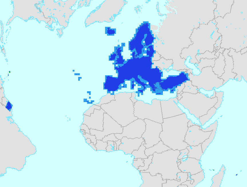
Copernicus EEA39 Boundary Layer with 250 m buffer (raster 100m), version 3, Jan. 2019
For the provision of land monitoring services within the Copernicus programme, a consistent, stable, sufficiently detailed boundary layer is required at EEA, which provides a “land mask” for the area that needs to be monitored.
This metadata refers to the Copernicus boundary layer covering EEA38 and the United Kingdom (former EEA39) in raster format (TIFF) at 100m resolution, including the French DOM (French Guiana GF, Guadeloupe GP, Martinique MQ, Mayotte YT and Reunion RE).
The dataset is based on a rasterisation of the Boundary Layer vector product, a generalisation of the Border Expert product to a scale of about 1 : 1 000 000 (a buffer of 250m is applied). This Border Expert product is based on EU-Hydro Coastline Version 3 from EEA, the EEA coastline for analysis Version 2, the EBM GISCO Hybrid Layer from EEA, the EuroGeographics EuroBoundary Map Version 12, the “Water and Wetness High Resolution Layer 2015” from EEA and the JRC-Global Surface Water Occurrence layer.
The production of this Border Product was coordinated by the European Environment Agency in the frame of the EU Copernicus programme.
Simple
Identification info
- Date (Creation)
- 2019-01-15
- Date (Publication)
- 2019-01-15
- Edition
-
03.00
- Citation identifier
- eea_r_3035_100_m_copernicus-buffer_p_2012-2018_v03_r00
- Point of contact
-
Organisation Individual Electronic mail address Website Role European Environment Agency
Point of contact European Environment Agency
Custodian
- Spatial representation type
- Grid
Spatial resolution
- Spatial resolution
- 100 m
- Topic category
-
- Boundaries
Extent
))
Temporal extent
- Time period
- 2012-01-01 2018-12-31
Extent
))
Extent
))
Extent
))
Extent
))
Extent
))
- Maintenance and update frequency
- As needed
- GEMET
-
-
administrative boundary
-
coast
-
- Continents, countries, sea regions of the world.
-
-
EEA38 (from 2020)
-
United Kingdom
-
- Spatial scope
-
-
European
-
- EEA topics
-
-
Land use
-
Resource constraints
- Access constraints
- Other restrictions
- Other constraints
- no limitations to public access
Resource constraints
- Use constraints
- Other restrictions
- Other constraints
-
License CC-BY 4.0 ( https://creativecommons.org/licenses/by/4.0/). Copyright holder: European Environment Agency (EEA).
- Language
- English
Data quality info
- Hierarchy level
- Dataset
Report
Result
- Title
-
Commission Regulation (EU) No 1089/2010 of 23 November 2010 implementing Directive 2007/2/EC of the European Parliament and of the Council as regards interoperability of spatial data sets and services
- Date (Publication)
- 2010-12-08
- Explanation
-
See the referenced specification
Resource lineage
- Statement
-
This dataset is based on EU-Hydro Coastline Version 3 from EEA, the EEA coastline for analysis Version 2, the EBM GISCO Hybrid Layer from EEA, the EuroGeographics EuroBoundary Map Version 12, the “Water and Wetness High Resolution Layer 2015” from EEA and the JRC-Global Surface Water Occurrence layer. The data is generalized to a scale of about 1 : 1 000 000 (a buffer of 250m is applied).
The production process is explained in the document provided with the dataset.
- Hierarchy level
- Dataset
Reference System Information
Reference System Information
- Code
- EPSG:3035
Reference System Information
Reference System Information
- Code
- EPSG:32740
Reference System Information
Reference System Information
- Code
- EPSG:32738
Reference System Information
Reference System Information
- Code
- EPSG:32620
Reference System Information
Reference System Information
- Code
- EPSG:32622
Metadata
- Metadata identifier
- 8a1b3765-a277-4505-a316-28bbe53a00b5
- Language
- English
- Character encoding
- UTF8
- Contact
-
Organisation Individual Electronic mail address Website Role European Environment Agency
Point of contact
Type of resource
- Resource type
- Dataset
- Metadata linkage
-
https://sdi.eea.europa.eu/catalogue/srv/api/records/8a1b3765-a277-4505-a316-28bbe53a00b5
- Date info (Creation)
- 2021-07-20T11:29:34.651Z
- Date info (Revision)
- 2025-10-09T11:02:19.405392Z
Metadata standard
- Title
-
ISO 19115/19139
- Edition
-
1.0
),POLYGON((-60.79%2014.383,-60.79%2014.883,-61.236%2014.883,-61.236%2014.383,-60.79%2014.383)),POLYGON((-60.994%2015.824,-60.994%2016.521,-61.815%2016.521,-61.815%2015.824,-60.994%2015.824)),POLYGON((45.306%20-13.08,45.306%20-12.578,44.938%20-12.578,44.938%20-13.08,45.306%20-13.08)),POLYGON((-51.614%202.106,-51.614%205.766,-54.621%205.766,-54.621%202.106,-51.614%202.106)),POLYGON((55.842%20-21.395,55.842%20-20.865,55.208%20-20.865,55.208%20-21.395,55.842%20-21.395))))