 EEA geospatial data catalogue
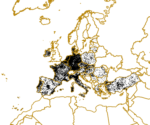
Urban Morphological Zones Changes 1990-2000 (vector) - version 16, Jun. 2013
Changes between UMZs in 1990 and UMZs in 2000 using CLC version 16.
Most changes are Positive changes, understood as areas of urban sprawl (i.e. new UMZ areas between 1990 and 2000), while negative changes describe the reduction of a certain UMZ between 1990 and 2000 (warning: some negative changes might be due to different interpretations between 1990-2000).
Simple
Identification info
- Date (Creation)
- 2013-06-28
- Edition
-
16.00
- Citation identifier
- eea_v_3035_100_k_umz-changes-1990-2000_p_2013_v16_r00
- Citation identifier
- DAT-63-en
- Point of contact
-
Organisation Individual Electronic mail address Website Role European Environment Agency
Custodian European Environment Agency
Point of contact
- Spatial representation type
- Vector
Spatial resolution
Equivalent scale
- Denominator
- 100000
- Topic category
-
- Planning cadastre
- Society
Extent
Temporal extent
- Time period
- 1990-01-01 2000-12-31
Extent
))
- Maintenance and update frequency
- As needed
- Place
-
-
Albania
-
Austria
-
Belgium
-
Bosnia and Herzegovina
-
Bulgaria
-
Croatia
-
Cyprus
-
Czechia
-
Denmark
-
Estonia
-
Finland
-
France
-
Germany
-
Hungary
-
Iceland
-
Ireland
-
Italy
-
Latvia
-
Liechtenstein
-
Lithuania
-
Luxembourg
-
North Macedonia
-
Malta
-
Montenegro
-
Netherlands
-
Norway
-
Poland
-
Portugal
-
Romania
-
Serbia
-
Slovakia
-
Slovenia
-
Spain
-
Sweden
-
Switzerland
-
Türkiye
-
Greece
-
- GEMET - INSPIRE themes, version 1.0
-
-
Land cover
-
- GEMET
-
-
urban environment, urban stress
-
social aspects, population
-
economy
-
environmental report
-
household
-
- EEA Management Plan
-
-
2014 1.8.3
-
- EEA topics
-
-
Buildings and construction
-
Land use
-
Environmental health impacts
-
Water
-
Urban sustainability
-
Resource constraints
- Use constraints
- Other restrictions
- Other constraints
-
License CC-BY 4.0 ( https://creativecommons.org/licenses/by/4.0/).
Resource constraints
- Access constraints
- Other restrictions
- Other constraints
- no limitations to public access
- Language
- English
- Character encoding
- UTF8
Data quality info
- Hierarchy level
- Dataset
Report
Result
- Title
-
Commission Regulation (EU) No 1089/2010 of 23 November 2010 implementing Directive 2007/2/EC of the European Parliament and of the Council as regards interoperability of spatial data sets and services
- Date (Publication)
- 2010-12-08
- Explanation
-
See the referenced specification
Resource lineage
- Statement
-
UMZ Changes have been calculated as well, by unioning both UMZ90 and UMZ00 and looking for those polygons existing only in one year (i.e. 1990 or 2000). Most changes are Positive changes, understood as areas of urban sprawl (i.e. new UMZ areas between 1990 and 2000), while negative changes describe the reduction of a certain UMZ between 1990 and 2000 (warning: some negative changes might be due to different interpretations between 1990-2000). Only countries with CLC in both years have changes in UMZ
Steps to follow:
1. Create a file geodatabase to keep the geometries
2. Union UMZ 1990 – 2000. Output:UMZ90_00_Full
3. Select ( "FID_UMZ1990" = -1 OR "FID_UMZ2000" = -1)
4. Export the selection. Output:UMZ90_00_FULL_select.shp
5. Selection of the real changes. Erasing
a. Select the countries with NO CLC in both years (90-00 and 00-06) from a NUTS0 Layer (as accurate as possible) selected_countries.shp
b. Clip UMZ90_00_FULL_select.shp + selected_countries.shp Output: Changes_90_00.shp
c. Manually work to remove the changes belonging to the selected countries. Small feature classes are left in these countries due to not perfect overlay among layers (NUTS0 and CLC) mainly in the coastal areas
6. Add and Calculate the Field “Area_ha”
7. Add a new field name “Change” type = Text with length = 1 to Change_90_00.shp
8. Delete unnecessary fields
9. Select “UMZ90_ID” = 0 and Calculate Value for “Change” = + . This means Urban Sprawl
10.Select “UMZ00_ID” = - 1 and Calculate Value for “Change” = - . This means Reduction of Urban Areas
11.Select “UMZ00_ID” <> - 1 and “UMZ90_ID” <> 0 and Calculate Value for “Change” = 0. This means no changes of Urban Areas
The complete methodology is described in the document RpD_UMZ_Methodology_f3.0.pdf which is stored in the same folder as the dataset.
- Hierarchy level
- Dataset
Reference System Information
Reference System Information
- Code
- EPSG:3035
Metadata
- Metadata identifier
- 9a353441-c28f-4733-acd0-16dde88f04ae
- Language
- English
- Character encoding
- UTF8
- Contact
-
Organisation Individual Electronic mail address Website Role European Environment Agency
Point of contact
Type of resource
- Resource type
- Dataset
- Metadata linkage
-
https://sdi.eea.europa.eu/catalogue/srv/api/records/9a353441-c28f-4733-acd0-16dde88f04ae
- Date info (Creation)
- 2014-03-24T16:38:17Z
- Date info (Revision)
- 2025-10-09T11:05:34.056258Z
Metadata standard
- Title
-
ISO 19115/19139
- Edition
-
1.0
)))