EEA marine assessment areas - version 3.0, Oct. 2022
The EEA marine assessment areas are harmonised units used for statistics. The EEA established the assessment areas for marine assessments to avoid jurisdictional issues on disputed maritime borders. The assessment areas dataset allows for a consistent geospatial approach for providing and updating spatial statistics of relevance for the implementation of EU legislation and progress monitoring of EU policies.
Simple
Identification info
- Date (Creation)
- 2022-09-28
- Date (Publication)
- 2022-10-14
- Edition
-
03.00
- Citation identifier
- eea_v_3035_100_k_eea-marine-assessment-areas_p_2022_v03_r00
- Point of contact
-
Organisation Individual Electronic mail address Website Role European Environment Agency
Point of contact European Environment Agency
Custodian
- Spatial representation type
- Vector
Spatial resolution
Equivalent scale
- Denominator
- 100000
- Topic category
-
- Environment
Extent
))
Temporal extent
- Time period
- 2022-01-01 2022-12-31
Extent
- Maintenance and update frequency
- As needed
- Continents, countries, sea regions of the world.
-
-
Baltic Sea
-
Black Sea
-
Northeast Atlantic Ocean (40W)
-
Mediterranean Sea
-
Resource constraints
- Access constraints
- Other restrictions
- Other constraints
-
The map should not be understood as representing international marine borders. To this end, the following disclaimer will accompany the map: "This map serves as a working mean only and shall not be considered as an official or legally-binding map representing marine borders in accordance with international laws. This map shall be used without prejudice to the agreements that will be concluded between Member States or between Member States and non-EU Countries in respect of their marine borders.".
- Other constraints
- no limitations to public access
Resource constraints
- Use constraints
- Other restrictions
- Other constraints
-
License CC-BY 4.0 ( https://creativecommons.org/licenses/by/4.0/). Copyright holder: European Environment Agency (EEA).
Associated resource
- Association Type
- Revision Of
- Metadata Reference
- Language
- English
Distribution Information
- Distribution format
-
-
SHP
-
GDB
-
- OnLine resource
-
Direct download
- OnLine resource
-
EEA website
Data quality info
- Hierarchy level
- Dataset
Report
Result
- Date (Publication)
- 2021-11-30
- Explanation
-
See the referenced specification
Resource lineage
- Statement
-
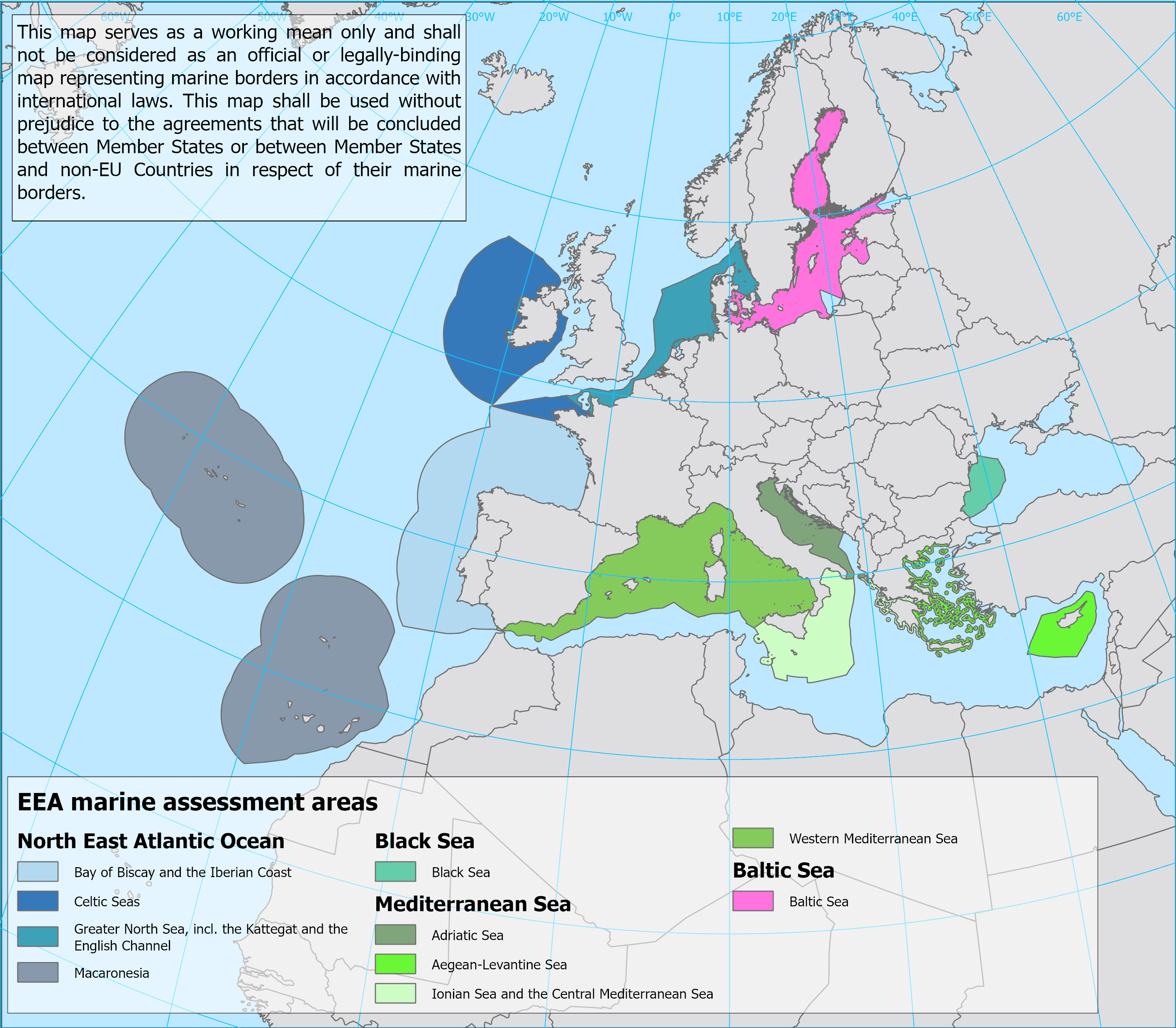
The EEA marine assessment areas are defined as the maritime area (water column and seabed) surrounding the EU countries whose outer limit is defined by the 200 NM boundary from the coast (possibly coinciding with formally recognised EEZ boundaries) or the equidistance (in cases of opposite neighbouring EU countries), or by the presence of a boundary defined by an agreed treaty. Landwards the dataset is harmonised with the "EEA coastline for analysis". Inner boundaries are based on the "EEA Marine waters for analysis" dataset, which is a harmonised version of the marine waters reported by EU Member States under the Marine Strategy Framework Directive (MSFD). Information about MSFD regions and subregions was assigned to the attributes of the assessment areas. National boundaries are omitted from the dataset and gaps and overlaps removed, resulting in 10 units that are named according to the assigned MSFD regions and subregions:
• Adriatic Sea
• Aegean-Levantine Sea
• Baltic Sea
• Bay of Biscay and the Iberian Coast
• Black Sea
• Celtic Seas
• Greater North Sea, incl. the Kattegat and the English Channel
• Ionian Sea and the Central Mediterranean Sea
• Macaronesia
• Western Mediterranean Sea.
Remarks in the delineation of this dataset compared to the previous version (one of the layers in "Europe Seas - version 1, Dec. 2018" dataset):
a. The boundary between Greater North Sea, incl. the Kattegat and the English Channel and Baltic Sea follows the delineation in the MSFD regions and subregions dataset version 2.
b. Outer (seaward) boundary is harmonised with the latest Bulgaria Marine Waters submission under MSFD Art.4 reporting.
c. United Kingdom marine waters are not part of this dataset following Brexit.
The dataset was assembled by ETC/ICM.
The map should not be understood as representing international marine borders. To this end, the following disclaimer will accompany the map: "This map serves as a working mean only and shall not be considered as an official or legally-binding map representing marine borders in accordance with international law. This map shall be used without prejudice to the agreements that will be concluded between Member States or between Member States and non-EU Countries in respect of their marine borders."
- Hierarchy level
- Dataset
Reference System Information
Reference System Information
- Code
- EPSG:3035
Metadata
- Metadata identifier
- a14375b6-13fa-44d2-9e01-f8bee5954dbb
- Language
- English
- Character encoding
- UTF8
- Contact
-
Organisation Individual Electronic mail address Website Role European Environment Agency
Point of contact
Type of resource
- Resource type
- Dataset
- Metadata linkage
-
https://sdi.eea.europa.eu/catalogue/srv/api/records/a14375b6-13fa-44d2-9e01-f8bee5954dbb
- Date info (Creation)
- 2022-06-15T06:26:25.944Z
- Date info (Revision)
- 2025-11-05T15:33:27.856434Z
Metadata standard
- Title
-
ISO 19115/19139
- Edition
-
1.0
Overviews
Spatial extent
)))
Provided by
