 EEA geospatial data catalogue
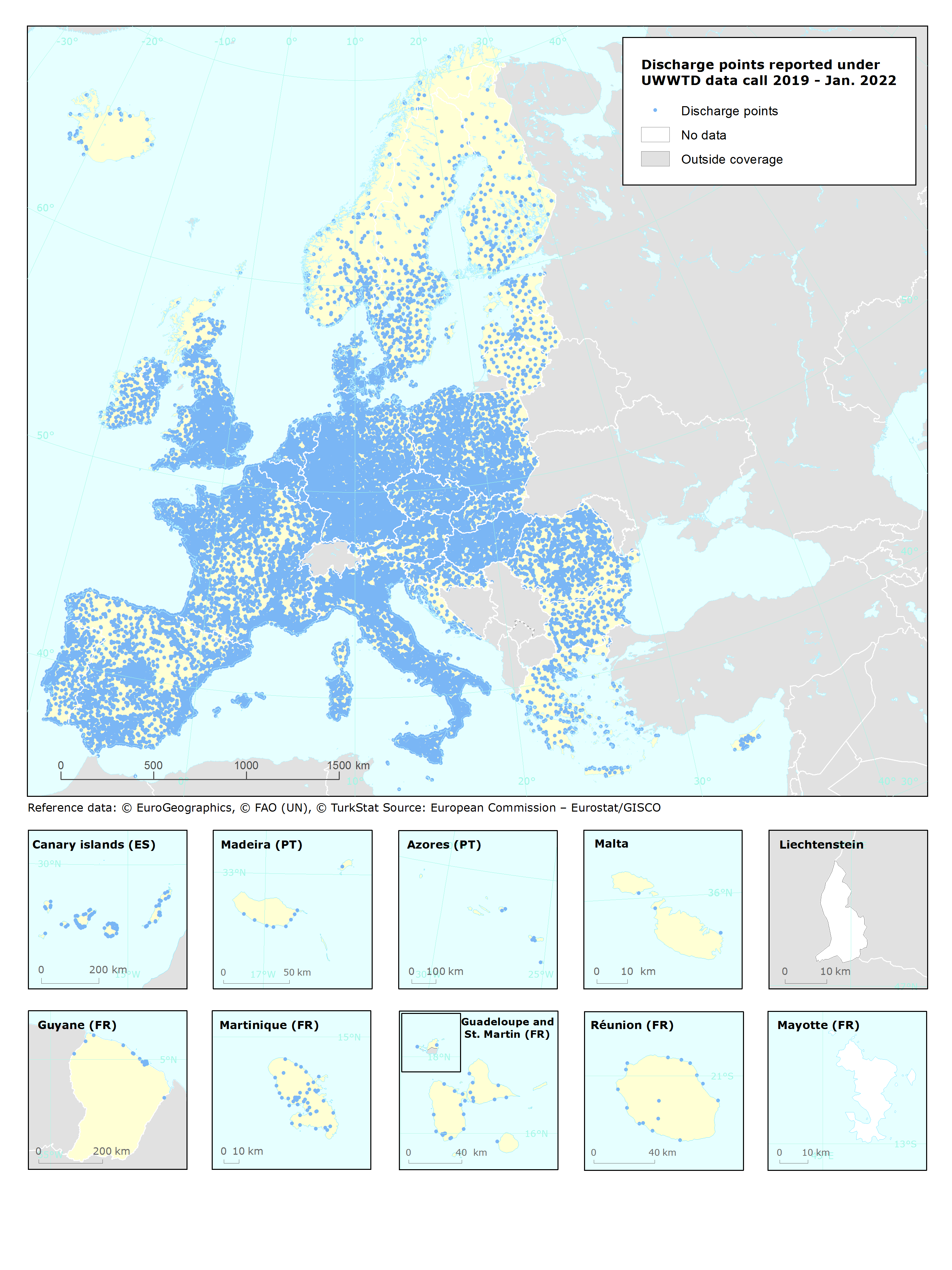
Urban Waste Water Treatment Directive, Discharge points reported under UWWTD data call 2019 - INTERNAL VERSION, Jan. 2022 (Spatial data)
UWWTD Discharge Points, Jan. 2022 is one of the datasets produced within the frame of the reporting under 11th UWWTD Art.15 reporting period (UWWTD data call 2019).
The Urban Waste Water Treatment Directive (UWWTD) (91/271/EEC) obliges Member States to report data on the implementation of the Directive upon request from the European Commission bi-annually. Reported data include receiving areas as designated under UWWTD, agglomerations, urban waste water treatment plants serving the agglomerations and points of discharges.
UWWTD_DischargePoints contains information on individual points of discharge from urban waste water treatment plants or collecting systems, including their coordinates of discharge, link to specific treatment plant, type of receiving area into which the effluent / wastewater is discharged, related waterbody (or river basin), information on the discharge on land and potential reuse of the treated waste water.
This metadata refers to the internal version of the dataset, that contains all reported discharge points, including inactive ones. Discharge points with obviously wrong coordinates were excluded only. The public dataset can be found under "Urban Waste Water Treatment Directive, Discharge points reported under UWWTD data call 2019 - PUBLIC VERSION, Jan. 2022".
In comparison to the previous version (Nov. 2020), late redeliveries and corrections provided by several countries during 2021 are included. Next, current revision is provided in GeoPackage and ESRI File geodatabase formats instead of shapefile used up to now, to avoid truncation of attribute names.
Simple
Identification info
- Date (Creation)
- 2020-11-15
- Date (Revision)
- 2022-01-21
- Edition
-
07.01
- Citation identifier
- eea_v_4258_100_m_uwwtd-disc-pts_i_2017-2018_v07_r01
- Status
- Superseded
- Spatial representation type
- Vector
Spatial resolution
- Spatial resolution
- 100 m
- Topic category
-
- Environment
Extent
))
Temporal extent
- Time period
- 2017-01-01 2018-12-31
Extent
- Maintenance and update frequency
- Biannually
- GEMET
-
-
waste water treatment
-
waste water discharge
-
water quality
-
waste water
-
urban waste water
-
Urban Waste Water Treatment Directive
-
urban waste water treatment
-
waste water treatment plant
-
- GEMET - INSPIRE themes, version 1.0
-
-
Utility and governmental services
-
- Continents, countries, sea regions of the world.
-
-
Norway
-
Iceland
-
EU27 (from 2020)
-
United Kingdom
-
- INSPIRE priority data set
-
-
Discharge points to receiving waters (Urban Waste Water Treatment Directive)
-
Directive 91/271/EEC
-
- EEA topics
-
-
Water
-
Resource constraints
- Access constraints
- Other restrictions
- Other constraints
- no limitations to public access
Resource constraints
- Use constraints
- Other restrictions
- Other constraints
-
The dataset contains parts which should not be made available for public access.
Associated resource
- Association Type
- Revision Of
- Language
- English
Distribution Information
- Distribution format
-
-
Geopackage
-
GDB
-
- OnLine resource
-
Direct download (Eionet authentication)
Data quality info
- Hierarchy level
- Dataset
Report
Result
- Title
- Commission Regulation (EU) No 1089/2010 of 23 November 2010 implementing Directive 2007/2/EC of the European Parliament and of the Council as regards interoperability of spatial data sets and services
- Date (Publication)
- 2010-12-08
- Explanation
-
See the referenced specification
Resource lineage
- Statement
-
Discharge points data were reported by Member states in tabular format. Spatial position of individual discharge points was specified by the geographical coordinates fields (longitude, latitude). These tabular data were checked, grouped into a common Pan-European dataset and transformed to the spatial data layer in GIS software. Discharge Points with obviously wrong coordinates were removed.
If the discharge point coordinates were not reported, given discharge point was not excluded (= missing information, coordinates are unknown); on the transformation from reported tabular format to the spatial point layer in GIS, records with missing coordinates were not transferred to the points visible in the data layer, of course, but they are available in the attribute table and their coordinates dcpLatitude and dcpLongitude in the attribute table are NULL.
- Hierarchy level
- Dataset
Reference System Information
Reference System Information
- Code
- EPSG:4258
Metadata
- Metadata identifier
- aca29c10-fcbf-4be6-82ca-c2dd7adc2974
- Language
- English
- Character encoding
- UTF8
- Contact
-
Organisation Individual Electronic mail address Website Role European Environment Agency
Point of contact
Type of resource
- Resource type
- Dataset
- Metadata linkage
-
https://sdi.eea.europa.eu/catalogue/srv/api/records/aca29c10-fcbf-4be6-82ca-c2dd7adc2974
- Date info (Creation)
- 2022-02-02T12:12:44.888Z
- Date info (Revision)
- 2025-10-09T11:08:25.577727Z
Metadata standard
- Title
-
ISO 19115/19139
- Edition
-
1.0
)))