 EEA geospatial data catalogue
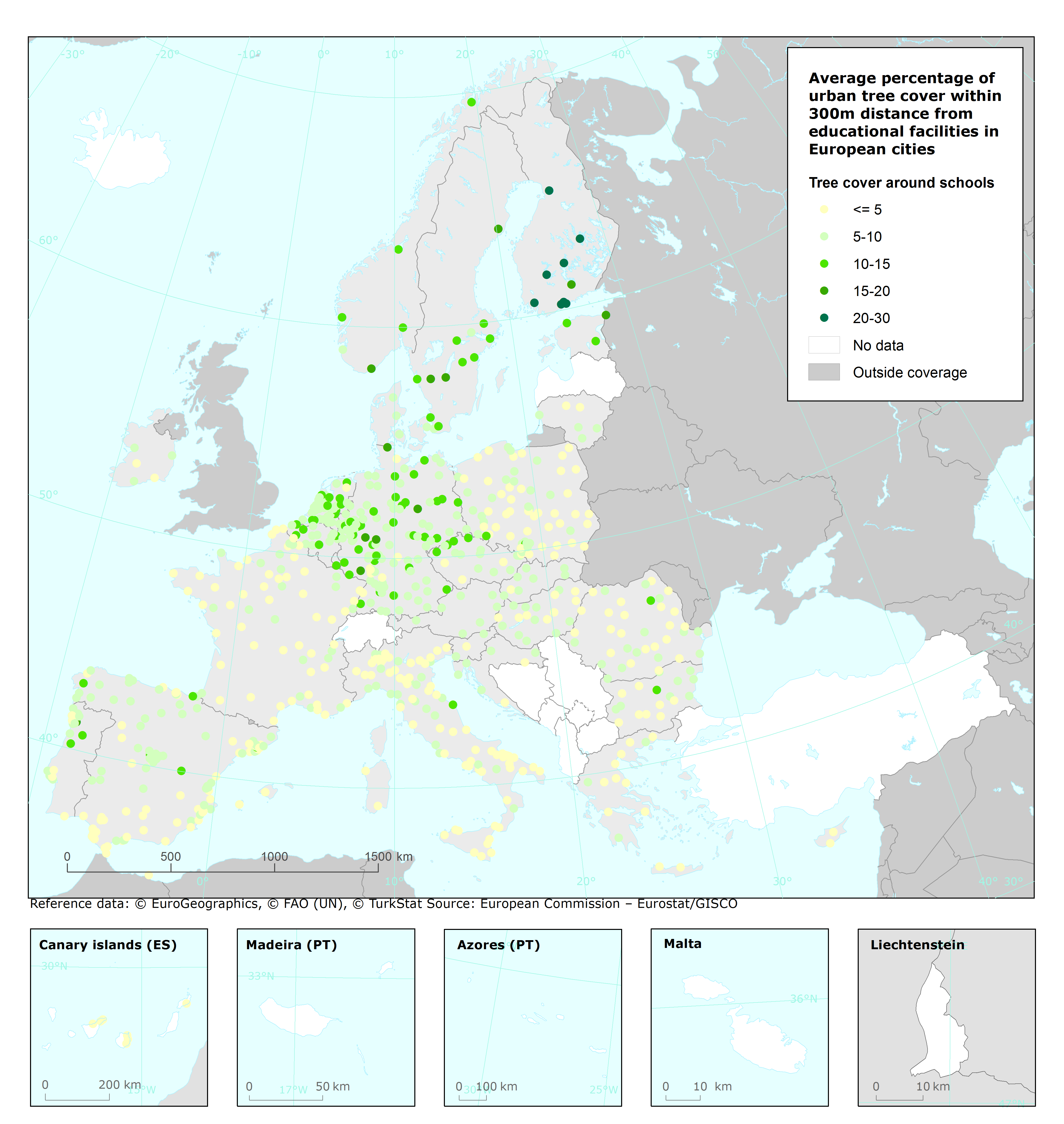
Average percentage of urban tree cover within 300m distance from educational facilities in European cities, 2020
This metadata refers to the vector dataset presenting, for Urban Audit cities across EEA member countries, the average percentage of urban tree cover within 300m distance from educational facilities. The data sources behind the dataset are the Eurostat data on location of educational facilities and the data contained in the EEA 'Urban tree cover' dashboard, which has been developed based on the Copernicus services: "Urban Atlas - Street Tree Layer 2018", "High Resolution Layer: Tree Cover Density 2018" and "Urban Atlas 2018".
Temporal coverage: 2018/2022 (green space data is from 2018; the educational facilities data is from 2022).
The data is included in the European Climate and Health Observatory: https://climate-adapt.eea.europa.eu/observatory. The European Climate and Health Observatory platform provides easy access to a wide range of relevant publications, tools, websites and other resources related to climate change and human health .
Simple
Identification info
- Date (Creation)
- 2022-08-01
- Date (Publication)
- 2022-10-03
- Edition
-
01.00
- Citation identifier
- eea_v_3035_1_mio_urban-tree-cover-schools_p_2020_v01_r00
- Point of contact
-
Organisation Individual Electronic mail address Website Role European Environment Agency
Point of contact European Environment Agency
Custodian
- Spatial representation type
- Vector
Spatial resolution
Equivalent scale
- Denominator
- 1000000
- Topic category
-
- Environment
Extent
))
Temporal extent
- Time period
- 2018-01-01 2020-12-31
Extent
- Maintenance and update frequency
- Not planned
- GEMET
-
-
green space
-
tree
-
green corridor
-
school
-
urban green
-
statistical information
-
- Continents, countries, sea regions of the world.
-
-
Liechtenstein
-
Norway
-
EU27 (from 2020)
-
- Spatial scope
-
-
European
-
Resource constraints
- Access constraints
- Other restrictions
- Other constraints
- no limitations to public access
Resource constraints
- Use constraints
- Other restrictions
- Other constraints
-
The download and usage of these data is subject to the acceptance of the following clauses:
The Commission agrees to grant the non-exclusive and not transferable right to use and process the Eurostat/GISCO geographical data downloaded.
The permission to use the data is granted on condition that:
(*) the data will not be used for commercial purposes;
(*) the source will be acknowledged. A copyright notice, as specified below, will have to be visible on any printed or electronic publication using the data downloaded from this page. (EN: © EuroGeographics for the administrative boundaries)
The above applies without prejudice of the License CC-BY 4.0 ( https://creativecommons.org/licenses/by/4.0/). Copyright holder: European Environment Agency (EEA).
Associated resource
- Association Type
- source
- Language
- English
Distribution Information
- Distribution format
-
-
GDB
-
Geopackage
-
- OnLine resource
-
European Climate and Health Observatory (Distribution of urban green spaces in relation to vulnerable groups)
- OnLine resource
-
Direct download
Data quality info
- Hierarchy level
- Dataset
Report
Result
- Title
- Commission Regulation (EU) No 1089/2010 of 23 November 2010 implementing Directive 2007/2/EC of the European Parliament and of the Council as regards interoperability of spatial data sets and services
- Date (Publication)
- 2010-12-08
- Explanation
-
See the referenced specification
Resource lineage
- Statement
-
The points representing the educational facilities located within the spatial extent of the Urban Audit cities were selected. For each educational facility, a buffer of 300m was created, within which the total area of land classified as urban tree cover was calculated. The total area of urban tree cover in the buffer was divided by the area of the buffer to obtain the percentage. An average (mean) of this percentage for all educational facilities was calculated per city.
The sources that underpin the dataset are: Urban Audit spatial boundaries 2018 (French cities based on the 2020 Urban Audit spatial boundaries): ( https://ec.europa.eu/eurostat/web/gisco/geodata/statistical-units/urban-audit), the Eurostat data on location of educational facilities ( https://gisco-services.ec.europa.eu/pub/education/), and the data contained in the EEA 'Urban tree cover' dashboard ( https://www.eea.europa.eu/data-and-maps/dashboards/urban-tree-cover), which was developed based on:
* Urban Atlas - Street Tree Layer 2018 (vector), Feb. 2021 ( https://sdi.eea.europa.eu/catalogue/srv/eng/catalog.search#/metadata/205691b3-7ae9-41dd-abf1-1fbf60d72c8c)
* High Resolution Layer: Tree Cover Density 2018 (raster 100m), Sep. 2020 ( https://sdi.eea.europa.eu/catalogue/srv/eng/catalog.search#/metadata/c7bf34ea-755c-4dbd-85b6-4efc5fd302a2)
* Urban Atlas 2018 (vector), Jul. 2021 ( https://sdi.eea.europa.eu/catalogue/srv/eng/catalog.search#/metadata/fb4dffa1-6ceb-4cc0-8372-1ed354c285e6)
- Hierarchy level
- Dataset
- Source
-
- https://ec.europa.eu/eurostat/web/gisco/geodata/statistical-units/urban-audit
- https://gisco-services.ec.europa.eu/pub/education/
- Tree Cover Density 2018 (raster 100 m), Europe, 3-yearly, Sep. 2020
- Urban Atlas Land Cover/Land Use 2018 (vector), Europe, 6-yearly, Jul. 2021
- Urban Atlas Street Tree Layer 2018 (vector), Europe, 6-yearly, Feb. 2021
Reference System Information
Reference System Information
- Code
- EPSG:3035
Metadata
- Metadata identifier
- d001467b-bd8b-4d46-bdcf-04aacc58b0c4
- Language
- English
- Character encoding
- UTF8
- Contact
-
Organisation Individual Electronic mail address Website Role European Environment Agency
Point of contact
Type of resource
- Resource type
- Dataset
- Metadata linkage
-
https://sdi.eea.europa.eu/catalogue/srv/api/records/d001467b-bd8b-4d46-bdcf-04aacc58b0c4
- Date info (Creation)
- 2022-09-28T08:02:30.937Z
- Date info (Revision)
- 2025-10-09T11:15:56.314729Z
Metadata standard
- Title
-
ISO 19115/19139
- Edition
-
1.0
)))