 EEA geospatial data catalogue
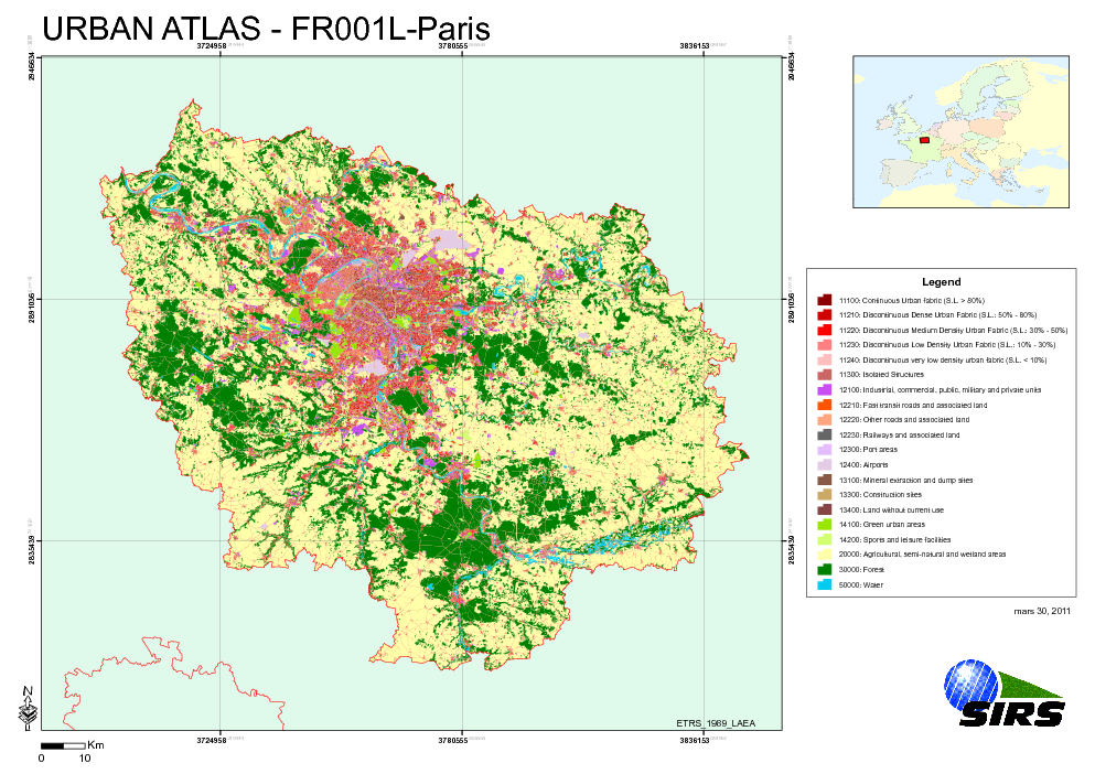
Urban Atlas - France - Paris
The Urban Atlas is providing pan-European comparable land use and land cover data for Large Urban Zones with more than 100.000 inhabitants as defined by the Urban Audit. Urban Atlas' mission is to provide high-resolution hotspot mapping of changes in urban spaces and indicators for users such as city governments, the European Environment Agency (EEA) and European Commission departments.
Simple
Identification info
- Date (Publication)
- 2010-05-28
- Date (Creation)
- 2010-05-28
- Citation identifier
- regio_v_32631_10_k_ua-fr001l_p_2005-2009_v01_r00
- Status
- Obsolete
- Point of contact
-
Organisation Individual Electronic mail address Website Role European Environment Agency
Point of contact
- Spatial representation type
- Vector
Spatial resolution
Equivalent scale
- Denominator
- 10000
- Topic category
-
- Society
Extent
))
Extent
Temporal extent
- Time period
- 2005-06-08 2009-04-01
- GEMET - INSPIRE themes, version 1.0
-
-
Land use
-
- GEMET
-
-
urban area
-
land use
-
- Place
-
-
France
-
Paris
-
- EEA topics
-
-
Land use
-
Resource constraints
- Use constraints
- Other restrictions
- Other constraints
-
License CC-BY 4.0 ( https://creativecommons.org/licenses/by/4.0/). Copyright holder: Directorate-General Enterprise and Industry.
Resource constraints
- Access constraints
- Other restrictions
- Other constraints
- no limitations to public access
- Language
- English
- Character encoding
- UTF8
Data quality info
- Hierarchy level
- Dataset
Report
Result
- Title
-
Commission Regulation (EU) No 1089/2010 of 23 November 2010 implementing Directive 2007/2/EC of the European Parliament and of the Council as regards interoperability of spatial data sets and services
- Date (Publication)
- 2010-12-08
- Explanation
-
See the referenced specification
Resource lineage
- Statement
-
Earth Observation (EO) Data used:
* Spot 5 10 m - 50392520708271110092J0 (XS) (Date: 2007/08/27)
* Spot 5 10 m - 50412530506081052342J0 (XS) (Date: 2005/06/08)
* Spot 5 10 m - 50422520604221034482J0 (XS) (Date: 2006/04/22)
* Spot 5 2,50 m - 50382500508291114021B2 (P) (Date: 2005/08/29)
* Spot 5 2,50 m - 50392510507131118412B2 (P) (Date: 2005/07/13)
* Spot 5 2,50 m - 50392520708271110072B3 (P) (Date: 2007/08/27)
* Spot 5 2,50 m - 50412510710231113032B0 (P) (Date: 2007/10/23)
* Spot 5 2,50 m - 50422510512171056482B3 (P) (Date: 2005/12/17)
* ALOS 2,50 m - AL_AV2_X_20070311_113513_DLR_6001_PRUTM (XS) (Date: 2007/03/11)
* ALOS 2,50 m - AL_AV2_X_20070311_113521_DLR_6001_PRUTM (XS) (Date: 2007/03/11)
* ALOS 2,50 m - AL_AV2_X_20070311_113529_DLR_6001_PRUTM (XS) (Date: 2007/03/11)
* ALOS 2,50 m - AL_AV2_X_20080427_105220_DLR_12025_PRUTM (XS) (Date: 2008/04/27)
* ALOS 2,50 m - AL_AV2_X_20080920_112219_DLR_14155_PRUTM (XS) (Date: 2008/09/20)
* ALOS 2,50 m - AL_AV2_X_20080920_112227_DLR_14155_PRUTM (XS) (Date: 2008/09/20)
* ALOS 10 m - AL_PSM_P_20070310_105503_DLR_5986_PRUTM (Date: 2007/03/10)
* ALOS 10 m - AL_PSM_P_20070310_105507_DLR_5986_PRUTM (Date: 2007/03/10)
* ALOS 10 m - AL_PSM_P_20070610_105511_DLR_7328_PRUTM (Date: 2007/06/10)
* ALOS 10 m - AL_PSM_P_20070610_105515_DLR_7328_PRUTM (Date: 2007/06/10)
* ALOS 10 m - AL_PSM_P_20070726_105459_DLR_7999_PRUTM (Date: 2007/07/26)
* ALOS 10 m - AL_PSM_P_20070726_105503_DLR_7999_PRUTM (Date: 2007/07/26)
* ALOS 10 m - AL_PSM_P_20080427_105212_DLR_12025_PRUTM (Date: 2008/04/27)
* ALOS 10 m - AL_PSM_P_20080427_105216_DLR_12025_PRUTM (Date: 2008/04/27)
* ALOS 10 m - AL_PSM_P_20080427_105220_DLR_12025_PRUTM (Date: 2008/04/27)
* ALOS 10 m - AL_PSM_P_20080427_105225_DLR_12025_PRUTM (Date: 2008/04/27)
* ALOS 10 m - AL_PSM_P_20080427_105229_DLR_12025_PRUTM (Date: 2008/04/27)
* ALOS 10 m - AL_PSM_P_20080514_105408_DLR_12273_PRUTM (Date: 2008/05/14)
* ALOS 10 m - AL_PSM_P_20080514_105412_DLR_12273_PRUTM (Date: 2008/05/14)
* ALOS 10 m - AL_PSM_P_20080514_105416_DLR_12273_PRUTM (Date: 2008/05/14)
* ALOS 10 m - AL_PSM_P_20080716_105558_DLR_13192_PRUTM (Date: 2008/07/16)
* ALOS 10 m - AL_PSM_P_20090320_110151_DLR_16795_PRUTM (Date: 2009/03/20)
* ALOS 10 m - AL_PSM_P_20090401_105739_DLR_16970_PRUTM (Date: 2009/04/01)
* ALOS 10 m - AL_PSM_P_20090401_105744_DLR_16970_PRUTM (Date: 2009/04/01)
* ALOS 10 m - AL_PSM_P_20090401_105748_DLR_16970_PRUTM (Date: 2009/04/01)
* ALOS 10 m - AL_PSM_P_20090401_105752_DLR_16970_PRUTM (Date: 2009/04/01)
- Hierarchy level
- Dataset
Reference System Information
- Reference system identifier
- OGP Surveying & Positioning Committee/urn:ogc:def:crs:EPSG:7.1:32631
Metadata
- Metadata identifier
- d2d17b33-db09-4534-aa96-2ad54f655ba3
- Language
- English
- Character encoding
- UTF8
- Contact
-
Organisation Individual Electronic mail address Website Role European Environment Agency
Point of contact
Type of resource
- Resource type
- Dataset
- Metadata linkage
-
https://sdi.eea.europa.eu/catalogue/srv/api/records/d2d17b33-db09-4534-aa96-2ad54f655ba3
- Date info (Creation)
- 2012-01-31T13:32:28Z
- Date info (Revision)
- 2025-10-09T11:16:25.870956Z
Metadata standard
- Title
-
ISO 19115/19139
- Edition
-
1.0
)))