 EEA geospatial data catalogue
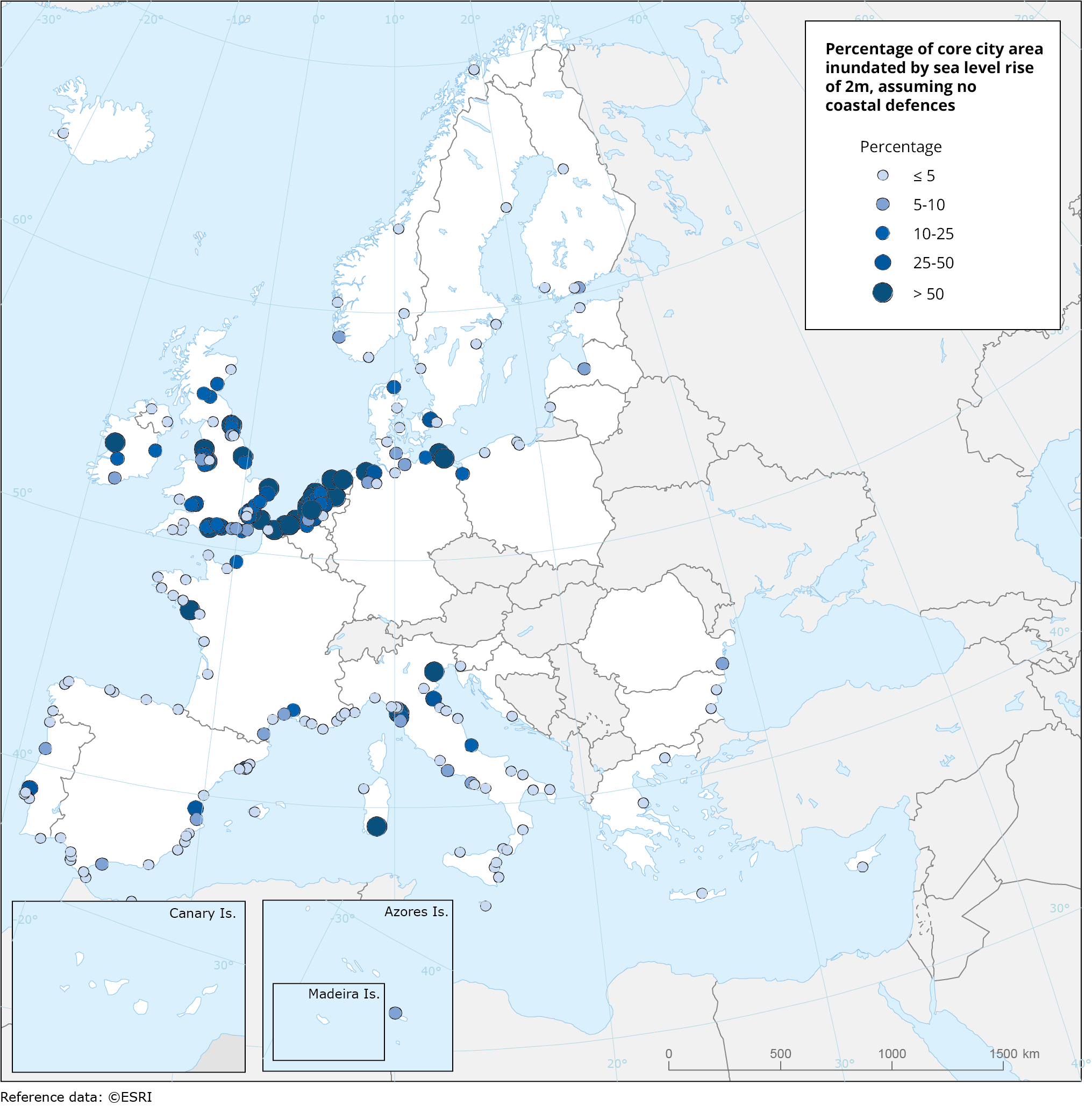
Area inundated with 2m sea level rise, Jan. 2020
This metadata refers to a dataset that shows the percentage of cities' administrative area (core city based on the Urban Morphological Zones dataset) inundated by the sea level rise of 2 metres, without any coastal flooding defences present for a series of individual coastal European cities (included in Urban Audit).
The dataset has been computed using the CReSIS (Centre for Remote Sensing of Ice Sheets) dataset for 2018.
Simple
Identification info
- Date (Creation)
- 2020-01-15T00:00:00
- Date (Publication)
- 2020-01-21T00:00:00
- Edition
-
01.00
- Citation identifier
- eea_v_4258_100_k_inundated-area-2m_p_2018_v01_r00
- Spatial representation type
- Vector
Spatial resolution
Equivalent scale
- Denominator
- 100000
- Topic category
-
- Environment
- Climatology, meteorology, atmosphere
Extent
Temporal extent
- Time period
- 2018-01-01 2018-12-31
Extent
Extent
))
- Maintenance and update frequency
- Not planned
- GEMET
-
-
climate
-
climate change impact
-
sea level rise
-
climate change adaptation
-
coastal flooding
-
flooding
-
city
-
- Continents, countries, sea regions of the world.
-
-
Croatia
-
Denmark
-
Romania
-
Greece
-
Netherlands
-
Italy
-
United Kingdom
-
Slovenia
-
Ireland
-
Germany
-
Malta
-
Finland
-
France
-
Estonia
-
Iceland
-
Sweden
-
Spain
-
Belgium
-
Bulgaria
-
Lithuania
-
Latvia
-
Poland
-
Cyprus
-
Portugal
-
- EEA topics
-
-
Climate adaptation
-
Water
-
Resource constraints
- Access constraints
- Other restrictions
Resource constraints
- Use constraints
- Other restrictions
- Other constraints
-
CReSIS (Centre for Remote Sensing of Ice Sheets) 2018, Lawrence, Kansas, USA. Digital Media. http://data.cresis.ku.edu/data.
Eurostat Urban Audit 2018 spatial units: https://ec.europa.eu/eurostat/web/gisco/geodata/statistical-units
- Language
- English
Data quality info
- Hierarchy level
- Dataset
Report
Result
- Title
- Commission Regulation (EU) No 1089/2010 of 23 November 2010 implementing Directive 2007/2/EC of the European Parliament and of the Council as regards interoperability of spatial data sets and services
- Date (Publication)
- 2010-12-08
- Explanation
-
See the referenced specification
Resource lineage
- Statement
-
Data on sea level rise was obtained from CReSIS (Centre for Remote Sensing of Ice Sheets) 2018, Lawrence, Kansas, USA. Digital Media. http://data.cresis.ku.edu/.
Coastal city centroids was obtained from Eurostat Urban Audit 2018 spatial units: https://ec.europa.eu/eurostat/web/gisco/geodata/statistical-units
Urban Morphological Zone (UMZ) from Urban Atlas 2012. UMZ is the reference unit for the city morphology. They are regarded as the best approximation of the “real” city form and defined as a set of urban areas laying less than 200 m apart, within the core city administrative boundaries.
- Hierarchy level
- Dataset
Reference System Information
Reference System Information
- Code
- EPSG:4258
Metadata
- Metadata identifier
- d96b007a-4e26-4dbd-8dd5-24dbe5c9b31f
- Language
- English
- Character encoding
- UTF8
- Contact
-
Organisation Individual Electronic mail address Website Role European Environment Agency
Point of contact
Type of resource
- Resource type
- Dataset
- Metadata linkage
-
https://sdi.eea.europa.eu/catalogue/srv/api/records/d96b007a-4e26-4dbd-8dd5-24dbe5c9b31f
- Date info (Creation)
- 2021-08-17T11:13:54.121Z
- Date info (Revision)
- 2025-10-09T11:17:50.6461Z
Metadata standard
- Title
-
ISO 19115/19139
- Edition
-
1.0
)))