 EEA geospatial data catalogue
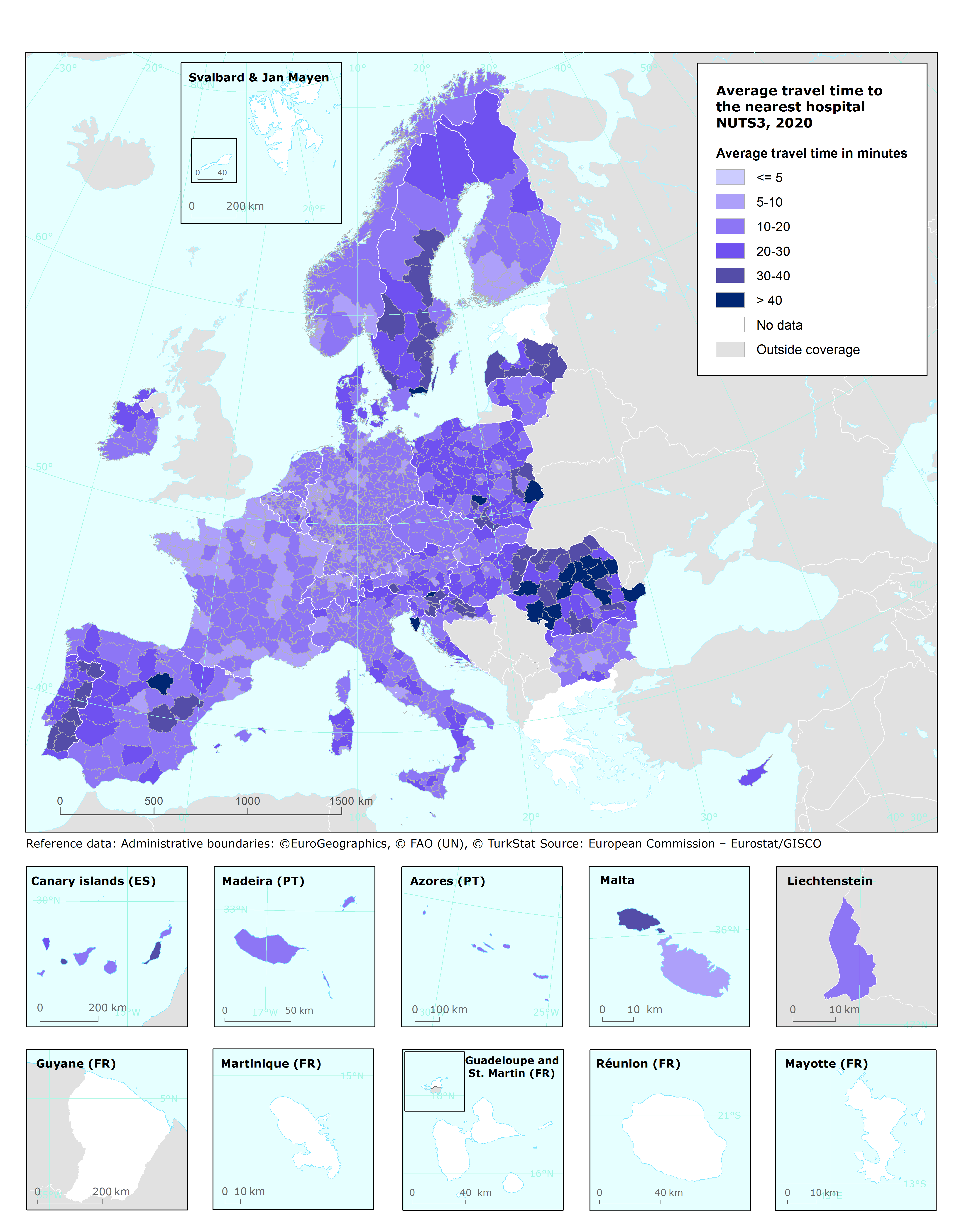
Average travel time to the nearest hospital in minutes, NUTS3 regions, 2020
This metadata refers to the vector dataset presenting, for NUTS3 regions, the average travel time to the nearest hospital in 2020. The data has been developed by Eurostat to measure how easily basic services can be reached by the resident population, based on spatial analyses of the location of healthcare facilities, combined with the road network. (note this could have been across a national border).
The data is included in the European Climate and Health Observatory: https://climate-adapt.eea.europa.eu/observatory. The European Climate and Health Observatory platform provides easy access to a wide range of relevant publications, tools, websites and other resources related to climate change and human health .
Simple
Identification info
- Date (Creation)
- 2022-11-01
- Date (Publication)
- 2022-11-21
- Edition
-
01.00
- Citation identifier
- eea_v_3035_100_k_avg-travel-time-to-hospital_p_2020_v01_r00
- Point of contact
-
Organisation Individual Electronic mail address Website Role European Environment Agency
Point of contact European Environment Agency
Custodian
- Spatial representation type
- Vector
Spatial resolution
Equivalent scale
- Denominator
- 100000
- Topic category
-
- Environment
Extent
))
Temporal extent
- Time period
- 2020-01-01 2020-12-31
Extent
- Maintenance and update frequency
- Not planned
- GEMET
-
-
travel
-
health care
-
public health
-
hospital
-
- Continents, countries, sea regions of the world.
-
-
Sweden
-
Saint-Martin
-
Romania
-
Czechia
-
Slovakia
-
Italy
-
Liechtenstein
-
Malta
-
Finland
-
Norway
-
France
-
Poland
-
Croatia
-
Denmark
-
Belgium
-
Netherlands
-
Germany
-
Cyprus
-
Ireland
-
Switzerland
-
Austria
-
Slovenia
-
Lithuania
-
Luxembourg
-
Latvia
-
Hungary
-
Portugal
-
Spain
-
- Spatial scope
-
-
European
-
- EEA topics
-
-
Environmental health impacts
-
Resource constraints
- Access constraints
- Other restrictions
- Other constraints
- no limitations to public access
Resource constraints
- Use constraints
- Other restrictions
- Other constraints
-
Reference geodata:
The geometry of the dataset derived from Eurostat NUTS 2021, Geostat population grid 2018, and the Health Care 2020 datasets must follow the terms and condition as stated here: https://ec.europa.eu/eurostat/en/about-us/policies/copyright.
The TomTom TeleAtlas road network database is the source of the transport infrastructure. The original TeleAtlas dataset is hosted at ESTAT and is not publicly available. Multinet: https://www.adci.com/tomtom/gis/ ).
All the above applies without prejudice of the License CC-BY 4.0 ( https://creativecommons.org/licenses/by/4.0/). Copyright holder: European Environment Agency (EEA).
- Language
- English
Distribution Information
- Distribution format
-
-
GDB
-
Geopackage
-
- OnLine resource
-
Direct download
- OnLine resource
-
ESRI Rest service
Data quality info
- Hierarchy level
- Dataset
Report
Result
- Title
- Commission Regulation (EU) No 1089/2010 of 23 November 2010 implementing Directive 2007/2/EC of the European Parliament and of the Council as regards interoperability of spatial data sets and services
- Date (Publication)
- 2010-12-08
- Explanation
-
See the referenced specification
Resource lineage
- Statement
-
This dataset has been computed using the point data of healthcare services (Eurostat; https://ec.europa.eu/eurostat/web/gisco/geodata/reference-data/healthcare-services) together with TomTom Multinet 2020 road data and Geostat population grid 2018 to calculate travel time to hospitals within NUTS3 regions. For more information, see here: https://ec.europa.eu/eurostat/statistics-explained/index.php?title=Health_statistics_at_regional_level#Health_care
- Hierarchy level
- Dataset
Reference System Information
Reference System Information
- Code
- EPSG:3035
Metadata
- Metadata identifier
- de17ed31-7474-4ff5-8f8c-bdd50c690a0a
- Language
- English
- Character encoding
- UTF8
- Contact
-
Organisation Individual Electronic mail address Website Role European Environment Agency
Point of contact
Type of resource
- Resource type
- Dataset
- Metadata linkage
-
https://sdi.eea.europa.eu/catalogue/srv/api/records/de17ed31-7474-4ff5-8f8c-bdd50c690a0a
- Date info (Creation)
- 2022-11-16T13:31:12.778Z
- Date info (Revision)
- 2025-10-09T11:18:44.088576Z
Metadata standard
- Title
-
ISO 19115/19139
- Edition
-
1.0
)))