 EEA geospatial data catalogue
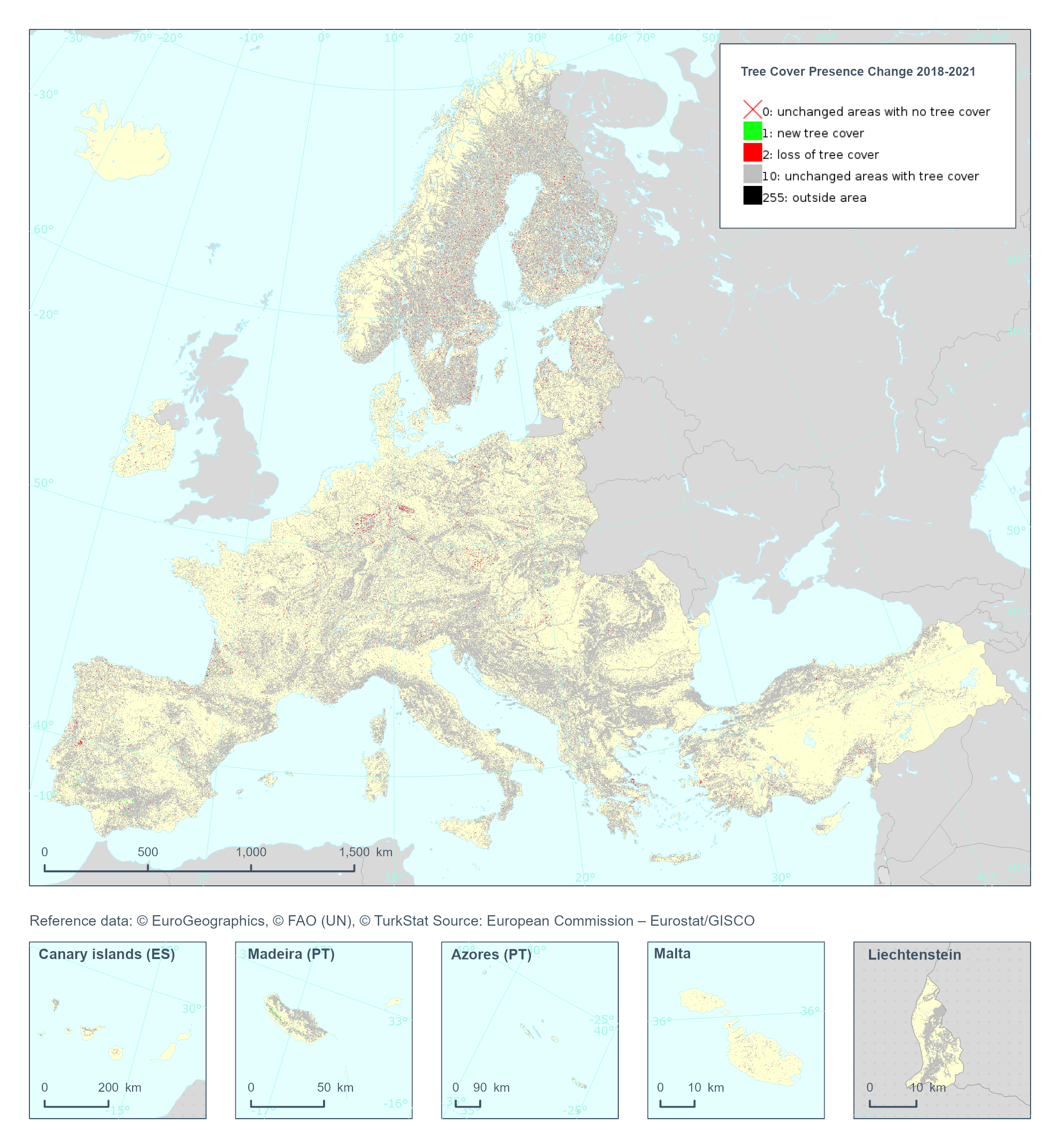
Tree Cover Presence Change 2018-2021(raster 20m), Europe, 3-yearly, Nov. 2024
The Copernicus High Resolution Layer Tree Cover Precense Change (TCPC) 2018-2021 raster product provides information on the change between the reference years 2018 and 2021 and consists of 4 thematic classes (unchanged areas with no tree cover / new tree cover / loss of tree cover / unchanged areas with tree cover). The class 255 = outside area is predefined by the 100m boundary layer and remains unchanged. This layer for previous reference year compraissions is called Tree Cover Change Mask (TCCM).
This dataset is provided in 20 meter rasters (fully conformant with the EEA reference grid) in 100 x 100 km tiles covering the EEA38 countries.
The production of the high resolution forest layers was coordinated by the European Environment Agency (EEA) in the frame of the EU Copernicus programme.
Confidence layer available for the dataset.
This dataset includes data from the French Overseas Territories (DOMs)
Simple
Identification info
- Date (Creation)
- 2024-04-09
- Date (Publication)
- 2024-12-01
- Edition
-
01.00
- Citation identifier
- copernicus_r_3035_20_m_tcpc-2018-2021_p_2018-2021_v01_r00
Identifier
- Spatial representation type
- Grid
Spatial resolution
- Spatial resolution
- 20 m
- Topic category
-
- Environment
- Imagery base maps earth cover
Extent
))
Extent
))
Extent
))
Extent
))
Extent
))
Extent
))
Extent
Temporal extent
- Time period
- 2018-01-01 2021-12-31
- Maintenance and update frequency
- As needed
- Continents, countries, sea regions of the world.
-
-
EEA38 (from 2020)
-
- EEA Management Plan
-
-
2024 6.5.24
-
Resource constraints
- Access constraints
- Other restrictions
- Other constraints
- no limitations to public access
Resource constraints
- Use constraints
- Other restrictions
- Other constraints
-
The Copernicus component is governed by Regulation (EU) No 2021/696 of the European Parliament and of the Council of 28 April 2021 establishing the Union Space Programme and the European Union Agency for the Space Programme and repealing Regulations (EU) No 912/2010, (EU) No 1285/2013 and (EU) No 377/2014 and Decision No 541/2014/EU. Within the Copernicus component, a portfolio of land monitoring activities has been delegated by the European Union to the European Environment Agency (EEA) and the DG Joint Research Centre of the European Commission.
The Copernicus land monitoring products and services are made available on a principle of full, open and free access, as established by the Commission Delegated Regulation (EU) No 1159/2013 of 12 July 2013.
Free, full and open access to the products and services of the Copernicus Land Monitoring Service is made on the conditions that:
1. When distributing or communicating Copernicus Land Monitoring Service products and services (data, software scripts, web services, user and methodological documentation and similar) to the public, users shall inform the public of the source of these products and services.
2. Where the Copernicus Land Monitoring Service products and services have been adapted or modified by the user, the user shall clearly state this.
3. Users shall make sure not to convey the impression to the public that the user's activities are officially endorsed by the European Union.
- Language
- English
- Character encoding
- UTF8
Distribution Information
- Distribution format
-
-
GTiff
-
- OnLine resource
-
HRL_TCF:TCPC_C2018-2021
CLMS_HRL_TreeCoverPresenceChange_C2018-2021_R20m
- OnLine resource
-
WEkEO Portal
- OnLine resource
-
Product Information & Technical Documentation
Data quality info
- Hierarchy level
- Dataset
Report
Result
- Title
- Commission Regulation (EU) No 1089/2010 of 23 November 2010 implementing Directive 2007/2/EC of the European Parliament and of the Council as regards interoperability of spatial data sets and services
- Date (Publication)
- 2010-12-08
- Explanation
-
See the referenced specification
Resource lineage
- Statement
-
The change detection approach for the Tree Cover Presence Change (TCPC) considers the difference in the probabilities of all tree cover classes. The differences have been visually checked for each production unit to calibrate two thresholds for gain and losses, respectively. The resulting categorical layer is aggregated to 20m and an MMU of 1ha is applied.
This dataset is a continuation of the HRL Tree Cover Change Mask (TCCM) timeseries, generated since the 2012-2015 comparison. The models and input data used to generate the product have evolved and therefore higher quality is to be expected as the timeseries progress.
Quality assurance follows the ISO9000 standards for Quality Management and comprises of dedicated procedures of ongoing quality checks (QA breakpoints) during implementation of the production chain, in order to keep persistent control over the various stages of production, assure fitness-for-purpose of the end-products and that all quality requirements are fulfilled. Priority has been given to the target thematic accuracies to be achieved by each product, as well as to the issues of product consistency (spatial, thematic, temporal) and homogeneity. Quality Assessment: The quality assessment has been performed according to INSPIRE Data Specifications. The data quality elements considered are:
(i) Completeness,
(ii) Logical Consistency,
(iii) Thematic Accuracy,
(iv) Temporal quality and
(v) Usability.
Each of them (excl. the Thematic Accuracy hereafter) forms a section in the QA/QC Procedures.
- Hierarchy level
- Dataset
Reference System Information
Reference System Information
- Code
- EPSG:3035
Reference System Information
Reference System Information
- Code
- EPSG:32738
Reference System Information
Reference System Information
- Code
- EPSG:32740
Reference System Information
Reference System Information
- Code
- EPSG:32620
Reference System Information
Reference System Information
- Code
- EPSG:32622
- Maintenance and update frequency
Metadata
- Metadata identifier
- ecdf6169-e330-4f02-8e12-083a1e1d24e7
- Language
- English
- Character encoding
- UTF8
- Contact
-
Organisation Individual Electronic mail address Website Role European Environment Agency
Point of contact
Type of resource
- Resource type
- Dataset
- Metadata linkage
-
https://sdi.eea.europa.eu/catalogue/srv/api/records/ecdf6169-e330-4f02-8e12-083a1e1d24e7
- Date info (Creation)
- 2025-01-17T14:40:56.805978Z
- Date info (Revision)
- 2025-10-09T11:21:28.285784Z
Metadata standard
- Title
-
ISO 19115/19139
- Edition
-
1.0
),POLYGON((-51.6142%202.1065,-51.6142%205.7653,-54.6203%205.7653,-54.6203%202.1065,-51.6142%202.1065)),POLYGON((-60.994%2015.8241,-60.994%2016.5206,-61.815%2016.5206,-61.815%2015.8241,-60.994%2015.8241)),POLYGON((-60.7907%2014.3837,-60.7907%2014.8826,-61.2351%2014.8826,-61.2351%2014.3837,-60.7907%2014.3837)),POLYGON((55.8416%20-21.3949,55.8416%20-20.8656,55.2087%20-20.8656,55.2087%20-21.3949,55.8416%20-21.3949)),POLYGON((45.3053%20-13.0793,45.3053%20-12.5781,44.9382%20-12.5781,44.9382%20-13.0793,45.3053%20-13.0793))))