 EEA geospatial data catalogue
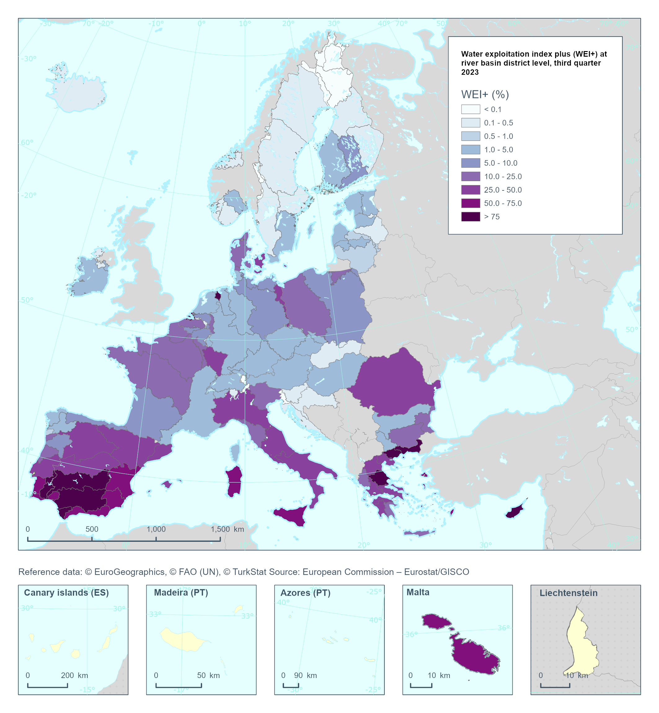
Water Exploitation Index plus (WEI+) at river basin level, 2023
This metadata covers the vector dataset of the Water Exploitation Index Plus (WEI+) at European river basin district levels for the years 2000 to 2023, broken down into four quarters each year.
Q1: Jan., Feb., Mar.
Q2: Apr., May, Jun.
Q3: Jul., Aug., Sep.
Q4: Oc., Nov., Dec.
The Water Exploitation Index plus (WEI+) aims to illustrate pressure on renewable water resources of a defined territory (river basin districts) in a given period (e.g. seasonal, annual) as a consequence of water use for human activities. Values above 20 % indicate that water resources are under stress, and above 40 % indicate severe stress and a clearly unsustainable use of freshwater resources (Raskin et al., 1997). The WEI+ has been estimated as the quarterly average per river basin district, for the years 2000-2023.
The downloadable data is provided in two datasets:
- Spatial data in SHP format.
- WEI+ data in Excel format, covering four quarters per year from 2000 to 2023.
The datasets can be linked via a spatial join using SHP.thematicId and Excel.spatialUnitIdentifier, ensuring the data is filtered by year and quarter.
Simple
Identification info
- Date (Creation)
- 2026-01-14
- Date (Publication)
- 2026-01-29
- Edition
-
01.00
- Citation identifier
- eea_v_3035_250_k_wei-riverbasin-level_p_2023_v01_r00
Identifier
- Codespace
-
doi.org
- Description
-
Digital Object Identifier (DOI)
- Point of contact
-
Organisation Individual Electronic mail address Website Role European Environment Agency
Point of contact European Environment Agency
Custodian
- Spatial representation type
- Text, table
- Spatial representation type
- Vector
Spatial resolution
Equivalent scale
- Denominator
- 250000
- Topic category
-
- Environment
- Climatology, meteorology, atmosphere
Extent
Extent
Extent
))
Extent
Temporal extent
- Time period
- 2000-01-01 2023-12-31
- Maintenance and update frequency
- Not planned
Resource constraints
- Access constraints
- Other restrictions
- Other constraints
- no limitations to public access
Resource constraints
- Use constraints
- Other restrictions
- Other constraints
-
License CC-BY 4.0 ( https://creativecommons.org/licenses/by/4.0/). Copyright holder: European Environment Agency (EEA).
- Language
- English
Distribution Information
- Distribution format
-
-
Microsoft Excel (.xls, .xlsx)
-
SHP
-
- OnLine resource
-
Direct download
- OnLine resource
-
Water exploitation index, plus (WEI+)
Eurostat Indicator (sdg_06_60)
- OnLine resource
-
Water scarcity conditions in Europe
EEA indicator
- OnLine resource
-
Digital Object Identifier (DOI)
Data quality info
- Hierarchy level
- Dataset
Report
Result
- Title
- Commission Regulation (EU) No 1089/2010 of 23 November 2010 implementing Directive 2007/2/EC of the European Parliament and of the Council as regards interoperability of spatial data sets and services
- Date (Publication)
- 2010-12-08
- Explanation
-
See the referenced specification
Resource lineage
- Statement
-
The Water Exploitation Index plus (WEI+) has been calculated as the quarterly average per country for the years 2000–2023. The WEI+ - referred to as the seasonal water scarcity - expresses total water consumption as a percentage of the renewable freshwater resources available in European countries. Each season corresponds to a calendar quarter: Q1 (January–March), Q2 (April–June), Q3 (July–September) and Q4 (October–December).
The WEI+ values presented may differ from nationally available figures, particularly for countries where data availability is limited in the WISE SoE – Water Quantity database (WISE 3) or in the Eurostat water database.
Water abstraction data were taken from WISE 3 (Waterbase - Water Quantity: https://www.eea.europa.eu/en/datahub/datahubitem-view/a4324714-784a-4763-b8b9-b8939ead87fe) and the Eurostat water database (Water statistics on national level (env_nwat): https://ec.europa.eu/eurostat/cache/metadata/en/env_nwat_esms.htm), although the time series contain significant gaps. To address this, extensive gap-filling was applied, and proxies were used to disaggregate annual data to quarterly.
Due to the limited availability of data on water use and return flows in WISE 3 (Waterbase - Water Quantity: https://www.eea.europa.eu/en/datahub/datahubitem-view/a4324714-784a-4763-b8b9-b8939ead87fe), return flows were estimated using sector-specific coefficients calculated from UWWTP capacities (Waterbase - UWWTD: Treatment Plants: https://www.eea.europa.eu/en/datahub/datahubitem-view/6ffd0af1-64eb-4cce-9970-0028e01ee64e), and the Eurostat population change dataset (Population (national level) (demo_pop): https://ec.europa.eu/eurostat/cache/metadata/en/demo_pop_esms.htm), among others.
The EEA calculates the Water Exploitation Index plus (WEI+) for Europe using a consistent approach for Renewable Water Resources (RWR). Data on precipitation, actual evapotranspiration, and outflow were obtained from WISE 3 (Waterbase - Water Quantity: https://www.eea.europa.eu/en/datahub/datahubitem-view/a4324714-784a-4763-b8b9-b8939ead87fe) and the Eurostat water database (([env_wat_res]): https://ec.europa.eu/eurostat/databrowser/view/env_wat_res/default/table?lang=en&category=env.env_wat.env_nwat) Renewable freshwater resources). Reservoir water balance data are available in WISE 3 (Waterbase - Water Quantity: https://www.eea.europa.eu/en/datahub/datahubitem-view/a4324714-784a-4763-b8b9-b8939ead87fe), but coverage across EIONET member countries is spatially and temporally incomplete. Copernicus CEMS EFAS ( https://10.0.95.61/cds.e3458969) and Copernicus Land ERA5 ( https://doi.org/10.24381/cds.68d2bb30) data have been used for gap filling in outflow and reservoir water balance, which may result in differences from national estimates.
The WEI+ for Switzerland and France may involve high uncertainties due to the use of modelled data as the baseline for the computation.
Italy has noted that, due to the approach used by EEA for RWR, the pan-European index does not accurately reflect the detailed water stress conditions in its river basins.
The WEI+ values for the following basins from Norway (i.e., NO1107, NO1108, NO1109, NO5107, and NO5109) represent the state of 2022 due to the lack of computed results for 2023.
The joint field in the spatial data is thematicId, and in the dataset wei_2000_2023_SDI_RiverBasinScale, the corresponding field is also spatialUnitIdentifier.
- Hierarchy level
- Dataset
Reference System Information
Reference System Information
- Code
- EPSG:3035
Metadata
- Metadata identifier
- f25b4715-d18b-4f87-b869-7e96fd385700
- Language
- English
- Character encoding
- UTF8
- Contact
-
Organisation Individual Electronic mail address Website Role European Environment Agency
Point of contact
Type of resource
- Resource type
- Dataset
- Metadata linkage
-
https://sdi.eea.europa.eu/catalogue/srv/api/records/f25b4715-d18b-4f87-b869-7e96fd385700
- Date info (Creation)
- 2026-01-28T18:49:37.40348Z
- Date info (Revision)
- 2026-01-30T13:16:39.953253Z
Metadata standard
- Title
-
ISO 19115/19139
- Edition
-
1.0
)))