 EEA geospatial data catalogue
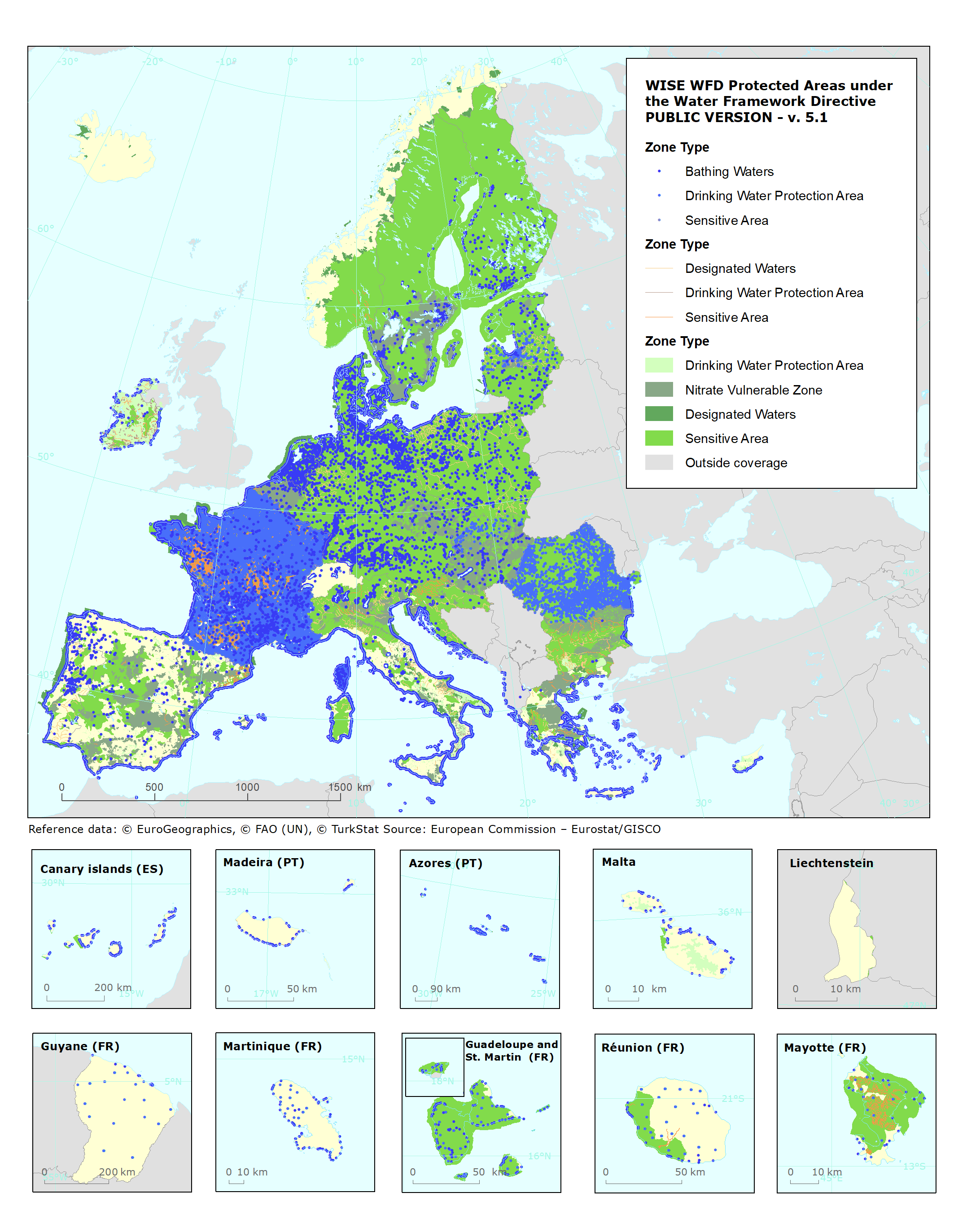
WISE WFD Protected Areas under the Water Framework Directive - PUBLIC VERSION - version 5.1, Jul. 2024
The data set contains the location of areas which have been designated as requiring special protection of their surface water and groundwater, or for the conservation of habitats and species directly depending on water, including economically significant aquatic species (e.g. shellfish).
According to the Article 6 of the Water Framework Directive (WFD, Directive 2000/60/EC), Member States shall ensure the establishment of a register of all areas lying within each River Basin District which have been designated as requiring special protection under specific Community legislation for the protection of their surface water and groundwater, or for the conservation of habitats and species directly depending on water, including the protection of Natura 2000 sites and economically significant aquatic species (e.g. shellfish).
According to Annex IV of the Water Framework Directive, the register shall include the following types of protected areas:
(i) areas designated for the abstraction of water intended for human consumption under WFD Article 7;
(ii) areas designated for the protection of economically significant aquatic species;
(iii) bodies of water designated as recreational waters, including areas designated as bathing waters under the Bathing Water Directive (BWD, Directive 76/160/EEC);
(iv) nutrient-sensitive areas, including areas designated as vulnerable zones under the Nitrates Directive (Directive 91/676/EEC) and areas designated as sensitive areas under Urban Waste Water Treatment Directive (UWWTD, Directive 91/271/EEC); and
The register shall also include "(v) areas designated for the protection of habitats or species where the maintenance or improvement of the status of water is an important factor in their protection, including relevant Natura 2000 sites designated under the Habitats Directive (Directive 92/43/EEC) and Birds Directive (Directive 79/409/EEC)."
The Natura 2000 protected sites are not included in the current data set.
This metadata refers to the public version (5.1) of this data set, which excludes areas that are no longer designated as well as drinking water protection areas if file access has been restricted by the data providers.
Simple
Identification info
- Date (Creation)
- 2024-08-30
- Date (Publication)
- 2024-12-13
- Edition
-
05.01
- Citation identifier
- eea_v_4326_250_k_wise-pareas_p_2016-2024_v05_r01
- Citation identifier
- DAT-221-en
- Point of contact
-
Organisation Individual Electronic mail address Website Role European Environment Agency
Point of contact
- Spatial representation type
- Vector
Spatial resolution
Equivalent scale
- Denominator
- 250000
- Topic category
-
- Environment
- Inland waters
- Geoscientific information
Extent
))
))
))
Extent
Temporal extent
- Time period
- 2016-01-01 2024-07-12
- Maintenance and update frequency
- As needed
- Continents, countries, sea regions of the world.
-
-
EU27 (from 2020)
-
Norway
-
Switzerland
-
Montenegro
-
Iceland
-
Albania
-
- INSPIRE priority data set
-
-
Directive 2000/60/EC
-
Urban waste water sensitive areas - nutrient sensitive areas (Water Framework Directive)
-
Bathing waters - recreational waters (Water Framework Directive)
-
Bathing water sites (Bathing Water Directive)
-
Designated waters (Water Framework Directive)
-
Drinking water protection areas (Water Framework Directive)
-
Directive 91/271/EEC
-
Directive 91/676/EEC
-
Directive 2006/7/EC
-
Protected areas (Water Framework Directive)
-
Nitrate vulnerable zones - nutrient sensitive areas (Water Framework Directive)
-
Sensitive area catchments (Urban Waste-Water Treatment Directive)
-
Sensitive areas, less sensitive areas and catchments (Urban Waste-Water Treatment Directive)
-
Sensitive areas (Urban Waste-Water Treatment Directive)
-
Less sensitive areas (Urban Waste-Water Treatment Directive)
-
- Reporting obligations
-
- Urban Waste Water Treatment Directive - Implementation
- Bathing Water Directive - Identification of Bathing Waters (until 2019)
- Urban Waste Water Treatment Directive - Situation Report
- Water Framework Directive - River Basin Management Plans - 2016 RBD XML data
- Bathing Water Directive - Monitoring and Classification of Bathing Waters (until 2019)
- Urban Waste Water Treatment Directive - National Implementation Programme
- Water Framework Directive - River Basin Management Plans - 2022 Spatial data
- Water Framework Directive - River Basin Management Plans - 2016 Spatial data
- Nitrates Directive - Report
- Water Framework Directive - River Basin Management Plans - 2022 Reporting
- Water Framework Directive - River Basin Management Plans - 2016 RBDSUCA XML data
- Water Framework Directive - River Basin Management Plans - 2022 RBD XML data
- Water Framework Directive - River Basin Management Plans - 2016 Reporting
- Bathing Water Directive - Identification of Bathing Waters
- Bathing Water Directive - Monitoring and Classification of Bathing Waters
- EEA Management Plan
-
-
2024 1.1.6
-
Resource constraints
- Access constraints
- Other restrictions
- Other constraints
- no limitations to public access
Resource constraints
- Use constraints
- Other restrictions
- Other constraints
-
For further information and specification regarding the use limitations and constraints please consult the file WISE_WFDProtectedArea_SpatialDataSets_2024-03-11_v5.0.pdf which is provided together with the data or click the WISE WFD protected area spatial data set in the links setion above.
Associated resource
- Association Type
- Revision Of
- Metadata Reference
- Language
- English
- Character encoding
- UTF8
Distribution Information
- Distribution format
-
-
Geopackage
-
- OnLine resource
-
https://sdi.eea.europa.eu/webdav/datastore/public/eea_v_4326_250_k_wise-pareas_p_2016-2024_v05_r01
- OnLine resource
-
Direct download
- OnLine resource
-
13
bathingWaters_point
- OnLine resource
-
https://water.discomap.eea.europa.eu/arcgis/rest/services/WISE_WFD/WFD_ProtectedArea_WM/MapServer
- OnLine resource
-
WISE WFD protected area spatial data set
Technical Report
Data quality info
- Hierarchy level
- Dataset
Report
Result
- Date (Publication)
- 2010-12-08
- Explanation
-
See the referenced specification
Resource lineage
- Statement
-
1. The WISE Water Framework Directive (WFD) Protected Area spatial data set includes:
* Drinking water protected areas.
* Designated areas, such as Fish protected areas and Shellfish protected areas.
* Nitrates vulnerable zones.
* Urban waste water sensitive areas.
* Bathing water protected areas.
2. The data source varies according to the type of Protected Area:
a.The drinking water protected areas and designated areas were reported to the European Commission during the second River Basin Management Plans WFD reporting process, due in 2022.
b. The nitrates vulnerable zones were reported to the European Commission under the Nitrates Directive 91/676/EEC reporting process, for the reference period 2016-2019.
c. The urban wastewater sensitive areas were reported to the European Commission under the Urban Waste Water Treatment Directive (UWWTD) reporting process, for the reference period 2022 and complemented with information reported in previous years or under the WFD reporting process.
d. The bathing water protected areas are reported under the Bathing Water Directive (BWD) annual reporting process. The data set includes information reported up to the 2023 season.
3. The information from the different data sources was converted to the WFD Protected Area data model. Detailed information about the structure and content of the spatial data sets reported in WFD2022 can be found in the WISE GIS Guidance. Note that some of the information that is mandatory in the WFD Protected Area data model is not available for all data sources.
4. The geometry of protected areas can be reported using polygons, polylines or points. The Geopackage include all three geometry types. Polygonal geometries are published as ProtectedArea, linear geometries as ProtectedAreaLine, and point geometries as ProtectedAreaPoint. ProtectedAreaPoint may also contain records for which the geometry is not available.
5. The geometry of the spatial objects is published in WGS 84 (urn:ogc:def:crs:EPSG::4326). The geometry of the objects was not edited or corrected. Topological and positional errors may exist. If more than one geometry type was reported for the same protected area, then polygons were preferred to polylines or points, and polylines were preferred to points. If more one geometry of the same type was reported for the same protected area, a geometry aggregate was created which may contain overlapping parts.
6. The size of spatial objects was calculated from the projected geometries in ETRS89-LAEA (urn:ogc:def:crs:EPSG::3035). For objects without proper geometry, the reported size is used if available.
7. The following access and use limitations are applicable to the WFD Protected Area data sets:
a. The information about drinking water protected areas is not published if the source file in the Central Data Repository (CDR) has been restricted by the Data Provider.
b. The use limitations and the access limitations and other constraints set by the Data Providers are described in the metadata files associated with each delivery in CDR.
- Hierarchy level
- Dataset
Reference System Information
Reference System Information
- Code
- EPSG:4326
Metadata
- Metadata identifier
- fe1aca53-a424-4472-b4fe-9c57ef0af51e
- Language
- English
- Character encoding
- UTF8
- Contact
-
Organisation Individual Electronic mail address Website Role European Environment Agency
Point of contact
Type of resource
- Resource type
- Dataset
- Metadata linkage
-
https://sdi.eea.europa.eu/catalogue/srv/api/records/fe1aca53-a424-4472-b4fe-9c57ef0af51e
- Date info (Creation)
- 2024-12-03T13:17:00.58836Z
- Date info (Revision)
- 2026-01-08T12:28:06.793009Z
Metadata standard
- Title
-
ISO 19115/19139
- Edition
-
1.0
),POLYGON((-50.8887%201.5818,-50.8887%2020.3034,-66.0059%2020.3034,-66.0059%201.5818,-50.8887%201.5818)),POLYGON((58.3154%20-22.4313,58.3154%20-10.8333,42.1436%20-10.8333,42.1436%20-22.4313,58.3154%20-22.4313))))