 EEA geospatial data catalogue
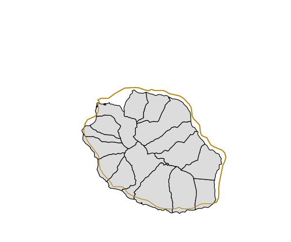
WISE GWB provisional dataset for Reunion island - PUBLIC VERSION, Oct. 2012
The sixteen Ground Water Basins of the Reunion Island are merged into a separate shape due to the location in the southern hemisphere resulting in a deviating map projection. All GWBs in Reunion are assigned to horizon 1.
The dbf tables of the shape files include the columns “EU_CD_GW” as the GWB identifier and “Horizon” describing the vertical positioning. The polygon identifier “Polygon_ID” was added subsequently, because some GWBs consist of several polygons with identical “EU_CD_GW”even in the same horizon.
Some further GWB characteristics are provided with the Microsoft Excel file “GWB_attributes_2012June.xls” including the column “EU_CD_GW”, which serves as a key for joining spatial and attribute data. There is no corresponding spatial data for GWBs in the Microsoft Excel table without an entry in column “EU_CD_GW”.
The spatial resolution is given for about a half of the GWBs in the column “Scale” of the xls file, which is varying between the MS from 1:10,000 to 1:1,000,000 and mostly in the range from 1:50,000 to 1:250,000.
Simple
Identification info
- Date (Publication)
- 2012-10-17
- Date (Creation)
- 2012-10-17
- Citation identifier
- eea_v_32740_1_mio_wise-gwb-public-reunion_p_2009-2011_V01_r00
- Status
- Obsolete
- Point of contact
-
Organisation Individual Electronic mail address Website Role European Environment Agency
Point of contact European Environment Agency
Custodian
- Spatial representation type
- Vector
Spatial resolution
Equivalent scale
- Denominator
- 1000000
- Topic category
-
- Inland waters
Extent
))
Extent
Temporal extent
- Time period
- 2009-01-01 2011-12-31
- GEMET - INSPIRE themes, version 1.0
-
-
Hydrography
-
Area management/restriction/regulation zones and reporting units
-
- GEMET
-
-
groundwater
-
aquifer
-
hydrography
-
- EEA topics
-
-
Water
-
Resource constraints
- Use constraints
- Other restrictions
- Other constraints
-
License CC-BY 4.0 ( https://creativecommons.org/licenses/by/4.0/). Copyright holder: European Environment Agency (EEA).
Resource constraints
- Access constraints
- Other restrictions
- Other constraints
- no limitations to public access
Associated resource
- Association Type
- Larger work citation
- Language
- English
- Character encoding
- UTF8
Data quality info
- Hierarchy level
- Dataset
Report
Result
- Title
-
Commission Regulation (EU) No 1089/2010 of 23 November 2010 implementing Directive 2007/2/EC of the European Parliament and of the Council as regards interoperability of spatial data sets and services
- Date (Publication)
- 2010-12-08
- Explanation
-
See the referenced specification
Resource lineage
- Statement
-
All GWBs located in Reunion are aggregated in the shape Reunion. The attribute table includes the fields “EU_CD_GW”, “Horizon” and the artificial polygon identifier “Polygon_ID”.
The linking between the shape file and the Microsoft Excel table GWB_attributes_2012June.xls, which comprises further attributes, has to be carried out using column EU_CD_GW as key for joining the dbf table of the shape file with the xls file.
- Hierarchy level
- Dataset
Reference System Information
Reference System Information
- Code
- EPSG:32740
Metadata
- Metadata identifier
- 16908436-12ec-414a-a78c-47eb38514345
- Language
- English
- Character encoding
- UTF8
- Contact
-
Organisation Individual Electronic mail address Website Role European Environment Agency
Point of contact
Type of resource
- Resource type
- Dataset
- Metadata linkage
-
https://sdi.eea.europa.eu/catalogue/srv/api/records/16908436-12ec-414a-a78c-47eb38514345
- Date info (Creation)
- 2012-10-18T12:37:29Z
- Date info (Revision)
- 2025-10-09T10:38:11.464284Z
Metadata standard
- Title
-
ISO 19115/19139
- Edition
-
1.0
)))