 EEA geospatial data catalogue
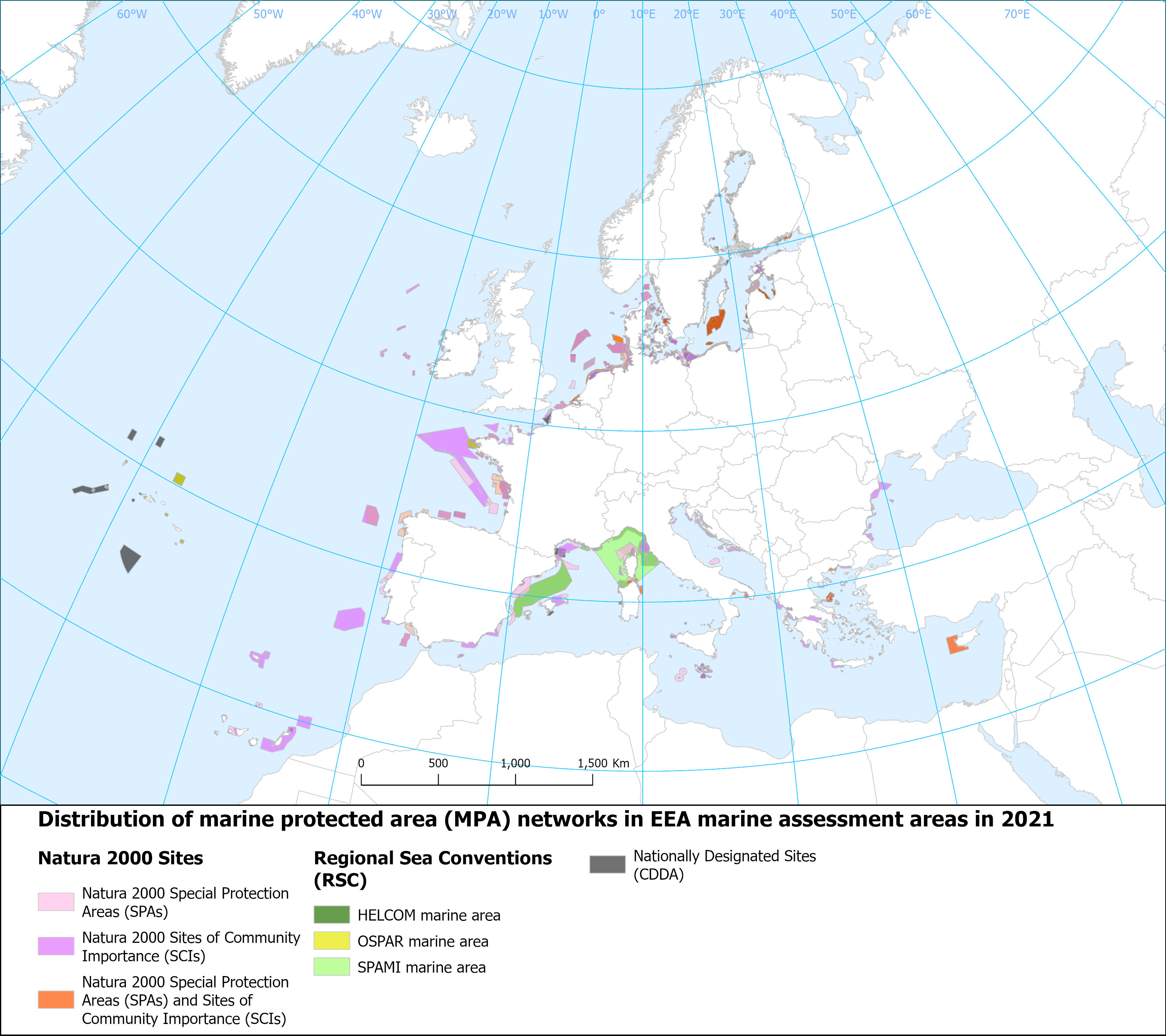
Marine Protected Areas (MPA) in EEA marine assessment areas, Ver. 2021
Marine protected areas are geographically distinct zones for safeguarding biodiversity, maintaining marine ecosystem health and the supply of ecosystem services. Marine protected areas operate at various scales and cover a range of protection levels and conservation objectives.
This dataset includes the delineation of marine protected areas in EEA marine assessment areas of the EU marine waters. The marine protected areas are those established under the framework of the EU nature directives (Natura 2000), Nationally designates areas (CDDA), and the Regional Sea Conventions (RSC) as reported in the respective official spatial and tabular databases. The data is reported until March 2022.
Simple
Identification info
- Date (Creation)
- 2022-11-04
- Date (Publication)
- 2023-02-10
- Edition
-
01.00
- Citation identifier
- eea_v_3035_100_k_mpa-in-marine-assessment-area_p_2021_v01_r00
- Purpose
-
Distribution of Marine Protected Area (MPA) networks in MPA assessment areas of the European regional seas.
- Point of contact
-
Organisation Individual Electronic mail address Website Role European Environment Agency
Point of contact European Environment Agency
Custodian
- Spatial representation type
- Vector
Spatial resolution
Equivalent scale
- Denominator
- 100000
- Topic category
-
- Environment
- Oceans
Extent
))
Extent
Temporal extent
- Time period
- 2021-01-01 2022-03-15
- Maintenance and update frequency
- As needed
- Continents, countries, sea regions of the world.
-
-
Mediterranean Sea
-
Northeast Atlantic Ocean (40W)
-
Adriatic Sea
-
Bay of Biscay
-
Celtic Sea
-
Ionian Sea
-
Mediterranean Sea, Western Basin
-
Baltic Sea
-
Black Sea
-
Aegean Sea
-
Resource constraints
- Access constraints
- Other restrictions
- Other constraints
- no limitations to public access
Resource constraints
- Use constraints
- Other restrictions
- Other constraints
-
License CC-BY 4.0 ( https://creativecommons.org/licenses/by/4.0/). Copyright holder: European Environment Agency (EEA).
Associated resource
- Association Type
- Revision Of
- Metadata Reference
- Language
- English
- Character encoding
- UTF8
Distribution Information
Data quality info
- Hierarchy level
- Dataset
Report
Result
- Title
- Commission Regulation (EU) No 1089/2010 of 23 November 2010 implementing Directive 2007/2/EC of the European Parliament and of the Council as regards interoperability of spatial data sets and services
- Date (Publication)
- 2010-12-08
- Explanation
-
See the referenced specification
Resource lineage
- Statement
-
This data shows the distribution and delineation of Marine Protected Areas (Natura 2000, CDDA, and RSC sites) in EEA marine assessment areas. The spatial extent of the EEA marine assessment areas was defined as the maritime area (water column and seabed) surrounding the EU-27 countries whose outer limit is defined by the 200 NM (nautical miles) boundary from the coast (possibly coinciding with formally recognised Economic Exclusive Zone (EEZ) boundaries) or the equidistance (in cases of opposite neighbouring EU countries), or by the presence of a boundary defined by an agreed treaty (for detailed information, see EEA marine assessment areas - version 3.0: https://sdi.eea.europa.eu/catalogue/srv/eng/catalog.search#/metadata/a14375b6-13fa-44d2-9e01-f8bee5954dbb).
The methodology and the procedure used for selecting the marine Natura 2000 and CDDA sites from the tabular and spatial data, and the RSC MPA shapefiles are the same as those outlined under Section 2.5 of the ETC/ICM Technical Report 3/2020 ( https://www.eionet.europa.eu/etcs/etc-icm/products/etc-icm-report-3-2020-spatial-analysis-of-marine-protected-area-networks-in-europe2019s-seas-iii), and datasets used are:
- EEA marine assessment areas ( https://sdi.eea.europa.eu/catalogue/srv/eng/catalog.search#/metadata/a14375b6-13fa-44d2-9e01-f8bee5954dbb)
- Natura 2000 tabular database and shapefile ( https://www.eea.europa.eu/data-and-maps/data/natura-13)
- OSPAR Convention MPAs shapefile ( https://odims.ospar.org/en/submissions/ospar_mpa_2021_07/)
- Helsinki Convention MPA (BSPA) shapefile ( https://metadata.helcom.fi/geonetwork/srv/eng/catalog.search#/metadata/d27df8c0-de86-4d13-a06d-35a8f50b16fa)
- Barcelona Convention MPA (SPAMI) shapefiles ( https://data.medchm.net/en/map/263/1/100/0)
- CDDA shapefile ( https://sdi.eea.europa.eu/catalogue/srv/eng/catalog.search#/metadata/28a5cf37-95d5-4758-9204-9eada51ebb8a)
The baseline information is based on MPA data reported until March 2022. The EEA marine assessment area dataset was used to select only those marine protected areas falling within the EEA marine assessment area. EEA have established assessment areas for marine assessments to avoid jurisdictional issues on disputed maritime borders. The EEA marine assessment areas allow for a consistent geospatial approach for providing and updating spatial statistics of relevance for the implementation of EU legislation and progress monitoring of EU policies.
- Hierarchy level
- Dataset
- Source
-
- EEA marine assessment areas - version 3.0, Oct. 2022
- Natura 2000 (vector) - version 2021, Apr. 2022
- https://metadata.helcom.fi/geonetwork/srv/eng/catalog.search#/metadata/d27df8c0-de86-4d13-a06d-35a8f50b16fa
- https://data.medchm.net/en/map/263/1/100/0
- Nationally designated areas for public access - version 20, Jun. 2022
- http://mpa.ospar.org/
Reference System Information
Reference System Information
- Code
- EPSG:3035
- Maintenance and update frequency
- As needed
Metadata
- Metadata identifier
- 5a8c5848-e131-4196-a14d-85197f284033
- Language
- English
- Character encoding
- UTF8
- Contact
-
Organisation Individual Electronic mail address Website Role European Environment Agency
Point of contact
Type of resource
- Resource type
- Dataset
- Name
-
dataset
- Metadata linkage
-
https://sdi.eea.europa.eu/catalogue/srv/api/records/5a8c5848-e131-4196-a14d-85197f284033
- Date info (Creation)
- 2023-01-06T12:22:49.847Z
- Date info (Revision)
- 2025-10-09T10:52:13.106645Z
Metadata standard
- Title
-
INSPIRE Metadata Implementing Rules: Technical Guidelines based on EN ISO 19115 and EN ISO 19119
- Edition
-
V. 2.0.1
)))