 EEA geospatial data catalogue
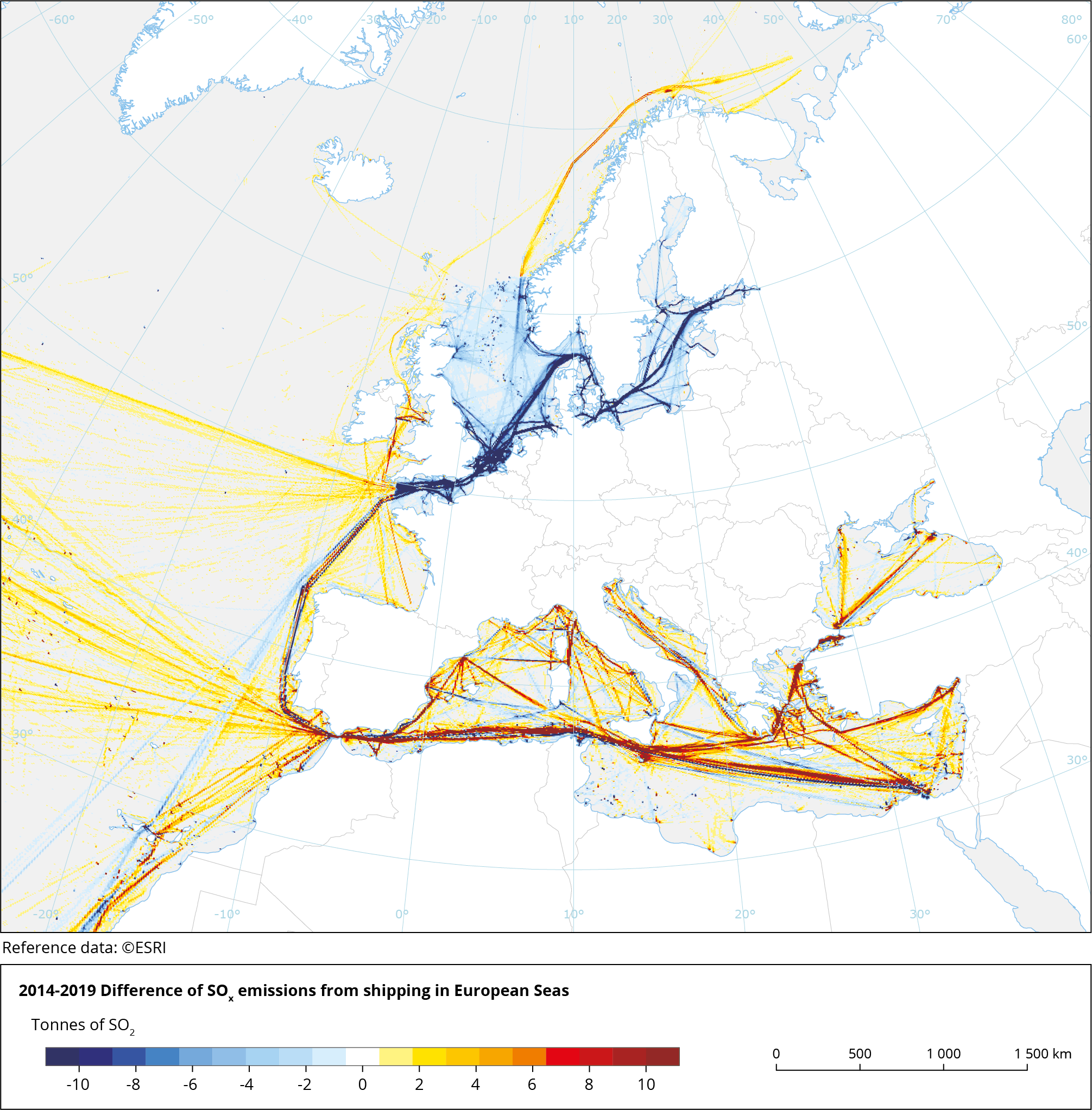
Difference in SO2 emissions in European shipping areas between 2014 and 2019, Mar. 2021
This metadata refers to the map showing the difference in SO2 emissions in European shipping areas between the years 2014 and 2019. The map indicates the changes in ship SO2 emissions, 2019 minus 2014 situation. The numerical values reported in the map are tonnes of SO2 per each grid cell. It can be seen that in 2019 SO2 emissions from shipping in the English Channel and the North and Baltic Seas are much lower compared to 2014 than those in areas outside the sulphur emission control areas (SECAs), including the Mediterranean Sea, where SO2 emissions have remained largely unaltered or increased.
The dataset has been prepared in the context of the development of the first European Maritime Transport Environmental Report (EMSA-EEA report, 2021: https://www.eea.europa.eu/publications/maritime-transport).
Simple
Identification info
- Date (Creation)
- 2021-03-05
- Date (Publication)
- 2021-03-31
- Edition
-
01.00
- Citation identifier
- eea_r_3035_10_km_emter-SO2-change-2014-2019_p_2014-2019_v01_r00
- Point of contact
-
Organisation Individual Electronic mail address Website Role European Environment Agency
Point of contact
- Spatial representation type
- Grid
Spatial resolution
- Spatial resolution
- 10 km
Spatial resolution
- Spatial resolution
- 5.5 km
- Topic category
-
- Environment
- Oceans
- Transportation
Extent
))
Temporal extent
- Time period
- 2014-01-01 2019-12-31
Extent
- Maintenance and update frequency
- Unknown
- GEMET
-
-
environment
-
maritime transport
-
marine pollution
-
sea
-
air pollution
-
transportation
-
ocean
-
environmental impact of transport
-
ship
-
environmental quality
-
emission
-
marine environment
-
- Continents, countries, sea regions of the world.
-
-
Baltic Sea
-
English Channel
-
Norwegian Sea
-
Bay of Biscay
-
North Sea
-
Celtic Sea
-
Iceland Sea
-
Black Sea
-
Barents Sea
-
Mediterranean Sea
-
Kattegat
-
Ionian Sea
-
Northeast Atlantic Ocean (40W)
-
Adriatic Sea
-
- Spatial scope
-
-
European
-
- EEA topics
-
-
Seas and coasts
-
Transport and mobility
-
Air pollution
-
Resource constraints
- Access constraints
- Other restrictions
- Other constraints
- no limitations to public access
Resource constraints
- Use constraints
- Other restrictions
- Other constraints
-
License CC-BY 4.0 ( https://creativecommons.org/licenses/by/4.0/). Copyright holder: European Environment Agency (EEA).
Associated resource
- Association Type
- Cross reference
- Metadata Reference
Associated resource
- Association Type
- Cross reference
- Metadata Reference
- Language
- English
Distribution Information
- Distribution format
-
-
netCDF
-
- OnLine resource
-
Direct download
- OnLine resource
-
Print friendly static map
Data quality info
- Hierarchy level
- Dataset
Report
Result
- Title
- Commission Regulation (EU) No 1089/2010 of 23 November 2010 implementing Directive 2007/2/EC of the European Parliament and of the Council as regards interoperability of spatial data sets and services
- Date (Publication)
- 2010-12-08
- Explanation
-
See the referenced specification
Resource lineage
- Statement
-
The dataset covers IHO sea regions inside the bounding box (excluding the Red Sea): Mediterranean Sea, Atlantic Ocean, North Sea, Baltic Sea, English Channel, Irish & British Seas, Black Sea, Norwegian Sea, Bay of Biscay, Arctic Ocean, Sea of Azov, Greenland Sea. This dataset is a subtraction of two output datasets from the STEAM model.
The data reports the difference between same variables between 2019 and 2014 values. The variables included in this dataset are: Antifouling paint (CuO) release to water, Antifouling paint (CuPyr) release to water, Antifouling paint (DCOIT) release to water, Antifouling paint (Zineb) release to water, Antifouling paint (ZnO) release to water, Antifouling paint (ZnPyr) release to water, Ash emissions to air, Ballast water dicharges to the sea, Bilge water discharge to the sea, Carbon monoxide (CO) emissions to air, Carbon dioxide (CO2) emissions to air, Elementary carbon (EC) emissions to air, Grey water (GW) discharge to water, Heavy Fuel Oil (HFO) used in ships, Liquid Natural Gas (LNG) used in ships, Marine Diesel Oil (MDO) used in ships, Number of Automatic Identification System (AIS) messages received, Marine Gas Oil (MGO) used in ships, Foodwaste nitrogen released to water, Sewage nitrogen released to water, Underwater noise energy released to water (63 Hz 1/3 octave band), Underwater noise energy released to water (125 Hz 1/3 octave band), Underwater noise energy released to water (2000 Hz 1/3 octave band), Nitrogen oxide (NOx) emissions to air, Organic carbon (OC) emissions to air, Transport work (Payload) done by ships, Number of person days spent onboard ships, Particulate matter (PM, smaller than 2.5 micrometers) emissions to air, Particle number emissions to air, Closed loop scrubber effluent release to water, Open loop scrubber effluent release to water, Sewage discharge to water, Sulphate (SO4) emissions to air, Sulphur oxide (SOx) emissions to air, Stern tube oil release to sea, Non-methane volatile organic compound (VOC) emissions to air.
These data are based on global AIS data from Orbcomm Ltd, IHS Markit ship fleet description and FMI STEAM ship model. Technical references for the STEAM model:
Jalkanen, J.-P. P., Brink, A., Kalli, J., Pettersson, H., Kukkonen, J., Stipa, T., … Stipa, T. (2009). A modelling system for the exhaust emissions of marine traffic and its application in the Baltic Sea area. Atmos. Chem. Phys., 9(4), 9209–9223. https://doi.org/10.5194/acp-9-9209-2009
Jalkanen, J. P., Johansson, L., Kukkonen, J., Brink, A., Kalli, J., & Stipa, T. (2012). Extension of an assessment model of ship traffic exhaust emissions for particulate matter and carbon monoxide. Atmospheric Chemistry and Physics, 12(5), 2641–2659. https://doi.org/10.5194/acp-12-2641-2012
Johansson, L., Jalkanen, J.-P., Kalli, J., & Kukkonen, J. (2013). The evolution of shipping emissions and the costs of regulation changes in the northern EU area. Atmospheric Chemistry and Physics, 13(22), 11375–11389. https://doi.org/10.5194/acp-13-11375-2013
Johansson, L., Jalkanen, J.-P., & Kukkonen, J. (2017). Global assessment of shipping emissions in 2015 on a high spatial and temporal resolution. Atmospheric Environment, 167, 403–415. https://doi.org/10.1016/j.atmosenv.2017.08.042
Jalkanen, J.-P., Johansson, L., Liefvendahl, M., Bensow, R., Sigray, P., Östberg, M., … Pajala, J. (2018). Modelling of ships as a source of underwater noise. Ocean Science, 14(6), 1373–1383. https://doi.org/10.5194/os-14-1373-2018
Jalkanen, J.-P., Johansson, L., Wilewska-Bien, M., Granhag, L., Ytreberg, E., Eriksson, K.M., Yngsell, D., Hassellöv, I.-M., Magnusson, K., Raudsepp, U., Maljutenko, I., Styhre, L., Winnes, H., Moldanova J. (2020). Modeling of discharges from Baltic Sea shipping, Ocean Science Discussions, https://doi.org/10.5194/os-2020-99, in review
The dataset has been prepared in the context of developing the first European Maritime Transport Environmental Report (EMSA-EEA report, 2021: https://www.eea.europa.eu/publications/maritime-transport).
- Hierarchy level
- Dataset
Reference System Information
Reference System Information
- Code
- EPSG:3035
Metadata
- Metadata identifier
- 9e5d71d4-de26-4abd-ab34-004e7d2d3fb9
- Language
- English
- Character encoding
- UTF8
- Contact
-
Organisation Individual Electronic mail address Website Role European Environment Agency
Point of contact
Type of resource
- Resource type
- Dataset
- Metadata linkage
-
https://sdi.eea.europa.eu/catalogue/srv/api/records/9e5d71d4-de26-4abd-ab34-004e7d2d3fb9
- Date info (Creation)
- 2022-09-16T10:10:12.39Z
- Date info (Revision)
- 2025-10-09T11:06:10.812881Z
Metadata standard
- Title
-
ISO 19115/19139
- Edition
-
1.0
)))