 EEA geospatial data catalogue
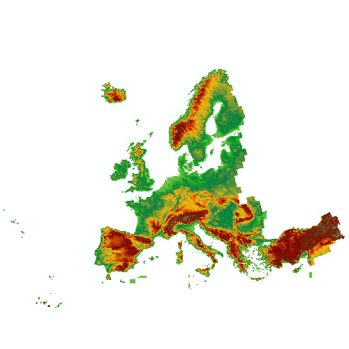
European Digital Elevation Model (EU-DEM)
EU-DEM is a digital surface model (DSM) at pan-European level representing the first surface as illuminated by the sensors. It is a hybrid product based on SRTM and ASTER GDEM data fused by a weighted averaging approach.
EU-DEM is not maintained anymore by the Copernicus Land Monitoring Service.
Copernicus DEM product publicly available at 30 m and 90 m spatial resolution can be accessed on the Copernicus Data Space Ecosystem (CDSE). More information can be found here: https://dataspace.copernicus.eu/explore-data/data-collections/copernicus-contributing-missions/collections-description/COP-DEM
If you have further questions please contact the CLMS helpdesk at JRC-Copernicus-Land@ec.europa.eu
Simple
Identification info
- Date (Publication)
- 2016-04-20
- Citation identifier
- copernicus_eu-dem_s
- Citation identifier
- DAT-193-en
- Status
- Obsolete
- Point of contact
-
Organisation Individual Electronic mail address Website Role Copernicus Land Monitoring Service
Custodian European Environment Agency
Publisher
- Spatial representation type
- Grid
- Topic category
-
- Environment
- Imagery base maps earth cover
Extent
))
))
Temporal extent
- Time period
- 2000-01-01 2000-12-31
Temporal extent
- Time period
- 2011-01-01 2011-12-31
Associated resource
- Association Type
- Is composed of
- Metadata Reference
Associated resource
- Association Type
- Is composed of
- Metadata Reference
- Language
- English
- Character encoding
- UTF8
Metadata
- Metadata identifier
- d08852bc-7b5f-4835-a776-08362e2fbf4b
- Language
- English
- Character encoding
- UTF8
- Contact
-
Organisation Individual Electronic mail address Website Role European Environment Agency
Point of contact
Type of resource
- Resource type
- Series
- Metadata linkage
-
https://sdi.eea.europa.eu/catalogue/srv/api/records/d08852bc-7b5f-4835-a776-08362e2fbf4b
- Date info (Creation)
- 2022-09-29T14:13:22.006Z
- Date info (Revision)
- 2025-10-09T11:16:03.23953Z
Metadata standard
- Title
-
ISO 19115-3:2018
- Edition
-
1.0
),POLYGON((-13.4198%2027.6375,-13.4198%2066.5662,-31.2684%2066.5662,-31.2684%2027.6375,-13.4198%2027.6375))))